Back Bay Fens
[1] Designed by Frederick Law Olmsted to serve as a link in the Emerald Necklace park system, the Fens gives its name to the Fenway-Kenmore neighborhood.
It is essentially an ancient spot of saltwater marshland that has been surrounded by dry land, disconnected from the tides of the Atlantic Ocean, and landscaped into a park with fresh water within.
When Boston was settled in the early 17th century the Shawmut Peninsula on which it was built was connected to Roxbury by a spit of sandy ground called "The Neck."
Olmsted's challenge was to restore the spot of marsh which was preserved into an ecologically healthy place that could also be enjoyed as a recreation area.
In 1941, at the outbreak of United States involvement in World War II, citizens planted a victory garden within the Fens.
A crescent-shaped bridge crossed over the Boston and Albany Railroad, connecting the Commonwealth Avenue Mall with the Fens at Gaston Square.
[6] The construction of the Massachusetts Turnpike Extension in the 1960s caused the removal of the curved bridge, separating the entrance (now Charlesgate Park) from the rest of the Fens.
It was replaced with the Bowker Overpass, which overshadows the remaining parkland; the Muddy River was moved to a small side channel, and the bust was relocated east along the Mall.
Westland Gate, a pair of marble monuments with lion's-head fountains feeding horse troughs on the side, frames the entrance.
The entrance was rebuilt several times as the Stony Brook was placed in conduits; the canal was filled in 1905 and the bridge demolished.
Initial plans called for it to continue as a parkway to Tremont Street and over Parker Hill, but high lands prices prevented that design.
[15] Within the main section of the Back Bay Fens (Boylston Street to Avenue Louis Pasteur), three road bridges and two footbridges cross the Muddy River.
[6] The west border of the Fens (where it meets the Riverway) is Brookline Avenue, which crosses the Muddy River on a wide bridge completed in 2016.
The Fenway originally crossed the Stony Brook canal at the Huntington Entrance on a five-arched bridge designed by the firm of Walker & Kimball.
Agassiz Road is a significant pedestrian link between the East and West Fenway neighborhoods though it provides only one-way vehicular circulation.
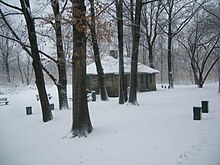
The building features a slate roof with distinctive wooden beams and walls of smooth stones of varying cuts.
The Stony Brook Gatehouse has since been decommissioned and in 2010 was converted into the headquarters for the Emerald Necklace Conservancy, and a visitors' center by Ann Beha Architects.
The Katharine Lee Bates monument is a freestanding granite tablet inset with a bronze plaque on Agassiz Road overlooking the Muddy River and Stony Brook gatehouse.
In the front of the memorial sits the bust of O'Reilly while the backside depicts a statue of Erin weaving a wreath of laurel and oak for her sons Poetry and Patriotism with Celtic calligraphy as a backdrop.
Several streets surrounding the Fens (Kilmarnock, Queensbury) were given names of Scottish peerages and towns mentioned in Robert Burns's literary works.
The statue is a standing portrayal of John Endecott dressed in early colonial attire, consisting of a jacket with a wide, square collar, knee breeches, buckle shoes, and a long cape.
According to inscriptions on one side of the monument, it was designed by Architect Ralph Weld Gray, and the statue was sculpted by Carl Paul Jennewein in 1936.
The rear of the monument features a large inscription, "Bequest George Augustus Peabody Esquire of Danvers, Massachusetts".
The main inscription features the seal of the Commonwealth of Massachusetts and the quote "STRONG, VALIANT JOHN WILT THOU MARCH ON, AND TAKE UP STATION FIRST, CHRIST CAL'D HATH THEE, HIS SOLDIER BE, AND FAIL NOT OF THY TRUST -EDWARD JOHNSON 1654".
Created by the George Robert White Fund in 1948, this is a grouping of three war memorials arranged around a circle, adjacent to the Keller Rose Garden, the Agassiz Bridge, and a concert grove that overlooks two gatehouses across the Muddy River.
At the south end of the rectangular portion of the garden is a statue that is a copy of the famous El Desconsol which was a gift to the City of Boston by Barcelona, Spain.
In 2001, the Emerald Necklace Conservancy, in cooperation with the Boston Parks and Recreation Department, convened landscape architects, horticultural specialists, and rosarians to develop a master plan for its renewal.
The original field house was demolished in the 1980s, due to neglect, and replaced with a simple Gothic styled storage structure.
The other was dedicated to neighborhood residents Brian and David Cobe in 1984 with a bronze plaque inset into a Roxbury puddingstone boulder adjacent to the diamond.
In 2010, as part of a public-private partnership between the City of Boston and Emmanuel College, the field was extensively renovated to collegiate standards, which necessitated the demolition of one of the stone bleachers.