Bad Camberg
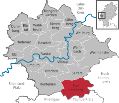
Bad Camberg lies north of the Taunus’s main ridge, 18 km southeast of Limburg an der Lahn, making it Middle Hesse’s southernmost town.
The greatest elevation in the central community – also called Bad Camberg – is the Kapellenhügel (“Chapel Hill”), which is somewhat more than 300 m high.
[3] To the Linear Pottery culture from the New Stone Age (5000-3000 BC), which draws its name from the ceramics that it produced, belong the oldest archaeological finds in the Camberg area.
The houses were mostly 20 to 25 m long and 5 to 7 m wide, consisting of five rows of posts, the three inner ones bearing the roof's weight, and the two outer ones the wattle-and-daub walls’.
[7] From the name Cagenberg developed Cainburg, Camburg, Kamberg and Camberg, and by other sources Cagenberc (1018), Kamberch (1156), Kahberg (1194) Kamberc (1197) and later Kaynburg.
In 1281, King Rudolph I granted town rights on the model of the Imperial city of Frankfurt am Main; these were renewed in 1300, 1336 and 1365.
Legend has it that after Epiphany in 1357, all the Camberg townsfolk were drunk and asleep when robber knights from Walsdorf came to try to rob the town.
However, there lived some magpies, who noticed the attempted robbery and gave out an alarm call, waking the townsfolk up, who then fended the attack off, putting the Walsdorf knights to flight.
From 1535 to 1794, the Amt of Camberg was in force, to which all current constituent communities belonged under the common administration of the House of Nassau and by the Electorate of Trier.
On 11 December 1969, the Hessian interior minister announced that suggestions for municipal rearrangements were to be worked out for all communities in the state.
The Dombach community representatives were of the opinion, however, that they should keep their village's autonomy until such time as the state chose to force an amalgamation.
Also, the Würges community representatives feared that building projects in their village would be shelved and that Camberg would become the town's cultural hub.
Walsdorf's and Steinfischbach's people had voted for Idstein and Waldems respectively so that the planned merger at the time agreed with the current town limits.
This agreement, however, was not recognized by the Hesse government, which demanded that Eisenbach, Haintchen and Oberselters be amalgamated with the community of Niederselters and suggested uniting Camberg with Erbach, Schwickershausen and Dombach.
The communities complained before the Hessian Administrative Court (Hessischer Verwaltungsgerichtshof) to get it to uphold the merger of Oberselters, Eisenbach and Haintchen at 1 January 1972 anyway.
When the Counts of Königstein died out in 1535, the Electorate of Trier occupied Camberg and acquired half the town.
In 1806 arose, out of Orange-Nassau, Nassau-Usingen and Nassau-Weilburg, the Duchy of Nassau, thereby ending the town's manifold overlordships.
The golden lions on the red field stem from the arms borne by the County of Diez, to which Bad Camberg belonged.
Many houses are grouped around the marketplace, which was a trading station on the High Road (Hohe Straße) from Cologne to Frankfurt.
The town's most popular sightseeing spot is the row of timber-frame houses that together make up the Amthof, the seat of the long defunct Amt.
Another important timber-frame building is the old Amt apothecary’s shop, whose foundations go back to 1330, and which was newly built in 1492 as a Burgmannenhaus for the Hattsteins.
The Electorate of Trier Auxiliary Bishop Johannes Maria von Herbain consecrated this church on 15 July 1781 in honour of the Apostles Peter and Paul.
The health resort park (Kurpark) in Bad Camberg was laid out as far back as the 18th century by the family Schütz von Holzhausen.
It is always held on the second weekend in October, although the actual church consecration festival is celebrated on 29 June (St. Peter's and St. Paul's).
Here mineral water is bottled under various brand names such as Nassauer Land, Oberselters and Bad Camberger Taunusquelle.
Bad Camberg lies on the A 3 (Cologne–Frankfurt), which goes back to one of the world's oldest trade roads, and on the Cologne-Frankfurt InterCityExpress line.
Already in the Bronze Age, which in Germany began about 1750 BC, the Hohe Straße (“High Road”) led through the Ems-Wörs drainage basin, running from Constantinople to Brussels.
This interchange was not in the original plans but was built later to let the communities in the Goldener Grund share in the transport and economic development.
This work on the road, which ran by the Untertortum west of what was then town limits, was after two or three years, owing to the great volume of traffic, once again utterly destroyed.
Owing to the Electorate of Trier Road-Building Ordinance of 1753, the citizens of the Amt of Camberg were obliged to perform compulsory labour on the road early in the year and in autumn.