Bad Kleinkirchheim
Bad Kleinkirchheim is at an average elevation of 1,087 m (3,566 ft) in a 5 km (3 mi) stretch of a glacial trough valley in the Gurktal Alps (Nock Mountains), between the Millstätter See and the upper Gurk River.
To the north and south of the valley, the hills rise relatively steeply to an elevation of about 2,000 m (6,600 ft), so that the only way in and out is by the B88 road which links the area to Radenthein in the west and Reichenau in the east.
It can be further divided into nine Ortschaften:[3] The remote and densely forested valley apparently was not settled in Roman times, when the area became part of the Noricum province in 15 BC.
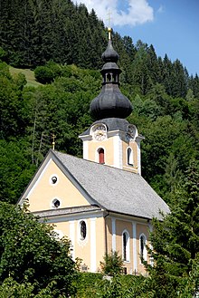
In a document dated 5 July 1166, in which Archbishop Conrad II of Salzburg confirms the donation of a chapel in the area to nearby Millstatt Abbey, there is mention of Chirchem as well as of a priest called Pabo.
In 1469 Millstatt Abbey was dissolved and its estates passed to the Knightly Order of Saint George, established by Emperor Frederick III to protect the area against the Ottoman forces who after the Fall of Constantinople already campaigned the Balkans and the Duchy of Carniola in the south.
However, when the Habsburg archduke Ferdinand II rose to power, he ceded the Millstatt estates with Kleinkirchheim to the Jesuits and made Roman Catholicism the official religion.
Nevertheless, Crypto-Protestants still managed to smuggle books and hold secret meetings during the Counter-Reformation, and according to the 1781 Patent of Toleration issued by Emperor Joseph II, a Protestant or a Jew would have nearly all the rights of a Catholic.
Bad Kleinkirchheim was shortly ruled within the French Illyrian Provinces during the Napoleonic Wars, but returned to the Austrian Empire in 1816.