Baffin Bay
Recent excavations also suggest that the Norse colonization of the Americas reached the shores of Baffin Bay sometime between the 10th and 15th centuries.
The English explorer John Davis was the first recorded European to enter the bay, arriving in 1585.
Their governor Thomas Smythe organized five expeditions to explore the northern coasts of Canada in search of a maritime passage to the Far East.
[12] Aboard Discovery, Baffin charted the area and named Lancaster, Smith, and Jones Sounds after members of his company.
[13] By the completion of his 1616 voyage, Baffin held out no hope of an ice-free passage and the area remained unexplored for another two centuries.
[15] More advanced scientific studies followed in 1928, in the 1930s and after World War II by Danish, American and Canadian expeditions.
The northwestern part of the bay remains one of the most seismically active regions in eastern Canada.
[3][20] The bay is less than 1,000 m (3,300 ft) deep near the coast, where the sea bottom is covered with gravel, crushed stone and sand.
In the centre, there is a deep pit called the Baffin Basin, reaching 2,136 m (7,008 ft) (see depth map), which is mostly covered in silt.
On the eastern periphery, in summer, the West Greenland Current transports water from the Atlantic Ocean to the North.
In its western part, the Baffin Island Current brings the Arctic waters to the south.
[2][21] Between May and July (sometimes April), a significant portion of navigable open water (polynya) forms at the extreme north of the bay, presumably due to the relatively warm Greenland Current.
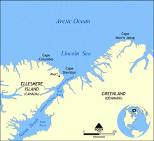
[3] With an area of about 80,000 km2 (31,000 sq mi) in summer, it is the largest polynya of the Canadian Arctic and covers the Smith Sound between the Ellesmere Island and Greenland.
[21][22] The North Water provides air to ice algae and zooplankton and is characterized by abundant fauna.
The seals and walrus occupy areas of fast ice, which is essential for giving birth and raising the pups.
[3][26][27] The US Geological Survey has estimated that at least 13% of the world's undiscovered oil deposits and 30% of the world's undiscovered gas pockets are located in the Arctic, with the seas around Greenland potentially holding large amounts of natural gas and lesser amounts of crude oil and natural-gas liquids.
[28][29] Accordingly, the Greenland authorities have offered a large number of off-shore concessions for potential hydrocarbon (oil and gas) extraction.