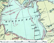
Hudson Bay
[11][12][13][14][15] The search for a western route to Cathay and the East Indies, which had been actively pursued since the days of Christopher Columbus and John Cabot, in the latter part of the 15th century, directly resulted in the first sighting of Hudson Bay by Europeans.
[17]: 185 In May 1612, Sir Thomas Button sailed from England with two ships to look for Henry Hudson, and to continue the search for the Northwest Passage to Asia.
[18] The HBC negotiated a trading monopoly from the English Crown for the Hudson Bay watershed, called Rupert's Land.
[22] French concessions in North America as outlined in the Treaty of Utrecht included: Hudson Bay region, Nova Scotia, and Newfoundland.
[citation needed] The HBC's trade monopoly was abolished in 1870, by a British Order in Council called the Deed of Surrender, ceded Rupert's Land to Canada, an area of approximately 3,900,000 km2 (1,500,000 sq mi), as part of the Northwest Territories.
[citation needed] The Port of Churchill was an important shipping link for trade with Europe and Russia until its closure in 2016 by owner OmniTRAX.
[24] The port and the Hudson Bay Railway were then sold to the Arctic Gateway Group—a consortium of First Nations, local governments, and corporate investors—in 2018.
This is because in the central summer months, heat waves can advance from the hot land and make the weather milder, with the result that the average temperature surpasses 10 °C (50 °F).
The bay receives water from various surrounding rivers and currents originating from the Foxe Basin in the north, resulting in a counterclockwise overall flow.
[2] At the extreme southern tip of the extension known as James Bay arises a humid continental climate with a longer and generally hotter summer.
By comparison, Magadan, in a comparable position at 59°N on the Eurasian landmass in the Russian Far East and with a similar subarctic climate, has an annual average of −2.7 °C (27.1 °F).
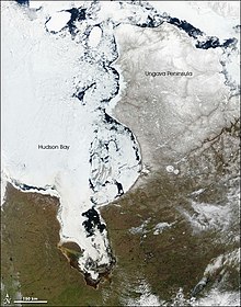
A steady increase in regional temperatures over the last 100 years has led to decreases in the extent of the sea ice in Hudson Bay by 19.5% per decade.
Although its exact effects are not fully understood currently, the cyclonic storms in the bay are responsible for synoptic variability of salinity along the coast.
The coastal area, located in a region characterized by permanently frozen layers of soil, known as permafrost, is a low-lying wetland that receives water from lakes and fast-flowing rivers.
The collection and interpretation of outcrop, seismic and drill hole data for exploration for oil and gas reservoirs within the Hudson Bay basin found that it is filled by, at most, 2,500 m (8,200 ft) of Ordovician to Devonian limestone, dolomite, evaporites, black shales, and various clastic sedimentary rocks that overlie less than 60 m (200 ft) of Cambrian strata that consist of unfossiliferous quartz sandstones and conglomerates, overlain by sandy and stromatolitic dolomites.
Only starting in the Late Ordovician and continuing into the Silurian did the gradual regional subsidence of this part of the Canadian Shield form the Hudson Bay basin.
Before deposition was terminated by marine regression, Upper Devonian black bituminous shale accumulated in the south-east of the basin.
[61][62][63][64] The remaining history of the Hudson Bay basin is largely unknown as a major unconformity separates Upper Devonian strata from glacial deposits of the Pleistocene.
Because of the irregular shapes of the colliding cratons, this collision trapped between them large fragments of juvenile crust, a sizable microcontinent, and island arc terranes, beneath what is now the centre of modern Hudson Bay as part of the Trans-Hudson Orogen.
Based upon this data, geophysicists and other Earth scientists concluded that the Laurentide Ice Sheet was composed of two large domes to the west and east of Hudson Bay.
[67] Earth scientists have disagreed about what created the semicircular feature known as the Nastapoka arc that forms a section of the shoreline of southeastern Hudson Bay.
In the same volume, John Tuzo Wilson[69] commented on Beals' interpretation and alternately proposed that the Nastapoka arc may have formed as part of an extensive Precambrian continental collisional orogen, linked to the closure of an ancient ocean basin.
The current general consensus is that it is an arcuate boundary of tectonic origin between the Belcher Fold Belt and undeformed basement of the Superior Craton created during the Trans-Hudson orogeny.
In December 2015, OmniTRAX announced it was negotiating a sale of the port, and the associated Hudson Bay Railway, to a group of First Nations based in northern Manitoba.
The Port and the Hudson Bay Railway were sold to Arctic Gateway Group—a consortium of First Nations, local governments, and corporate investors—in 2018.
Some of these were founded as trading posts in the 17th and 18th centuries by the Hudson's Bay Company, making them some of the oldest settlements in Western Canada.
With the closure of the HBC posts and stores, although many are now run by The North West Company,[77] in the second half of the 20th century, many coastal villages are now almost exclusively populated by Cree and Inuit.
In the 1950s, during the Cold War, a few sites along the coast became part of the Mid-Canada Line, watching for a potential Soviet bomber attack over the North Pole.