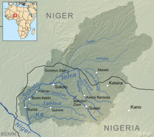
Bakolori Dam
[1] The dam has a capacity of 450 million cubic meters, with a reservoir covering 8,000 hectares extending 19 km (12 mi) upstream.
The area is subject to periodic droughts, and the desire for a stable water supply was one of the motives for constructing the dam.
The FAO report emphasized the importance of a gradual approach that would have minimal impact on existing land use patterns, in part because of lack of experience with irrigation projects in the region.
During the 1972 to 1974 study period, the scope of the project expanded to cover a single large dam and a large-scale mechanized irrigation scheme.
The dam is a 5.5 km (3 mi) earth-fill embankment, with a central concrete structure 360 m long and 48 m high incorporating a small 3 MW hydroelectric power plant.
Confronted by demonstrators in November 1979, the governor of Sokoto State, Shehu Kangiwa, promised to address all their grievances.
[3] The downstream floodplain farmers required large-scale water release before the growing season, with diminished flows later as they practiced flood recession agriculture.
[6] The dam significantly decreased peak flows and the depth, duration and extent of flooding downstream during the wet season.
The water is turbid, holding suspended soil particles that block the light and inhibit growth of submerged aquatic plants on which fish depend for food.
[2] Attempts to introduce new varieties of cowpea inter-cropped with millet, sorghum and groundnuts had little success due to the relatively low yield of this traditional crop and the high cost of the irrigation systems.
[14] The authors of a report on Wise Use of Wetlands published by UNESCO in 1988 concluded that "a more complete economic appraisal of the scheme at Bakolori would have been less favourable than the calculation upon which it was approved.