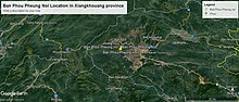
Ban Phou Pheung Noi
Phou Pheung mountain runs from east to west and is rocky, and is covered in tropical forests.
To the east, about 10 miles from Ban Phou Pheung Noi, is the Num Ngum 4 hydroelectric dam.
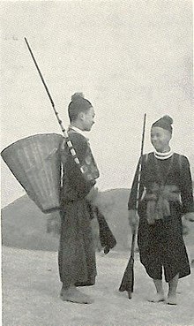
[5] Between 1952 and 1965, the Hmong hill tribes mainly lived in Ban Phou Pheung Noi, hunting, fishing, and burning the rainforest to clear land.
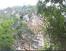
When Captain Kong Le overthrew the Royal Lao Government on August 10, 1960 in a coup d'état, Ban Phou Pheung Noi villagers took refuge in a cave on a cliff of Phou pheung mountain on the bank of the Nam Ngum River out of fear of being killed by Kong Le's military troops moving east through Muang Soui to Phonsavan and Plain of Jars.
When the hill tribes of the village saw the pilot and the co-pilot sitting with dark glasses in the helicopter, they believed they were Martians (Nyav-noj-neeg in Hmong).
[7] About three miles away, Lee Lue, a T-28 pilot employed by General Vang Pao and the US CIA,[8] was killed.
Some of the Yang families fled to Thailand, then immigrated to Western countries like Australia, Canada, France and the United States, for the most part after 1975.
The village of Ban Phou Pheung Noi is located between Sam Thong, Long Tieng,[23] to the southeast, Muang Soui to the north, Plain of Jars and Phonsavan to the east, and the royal capital Luang Prabang to the west and north.
[24] The three villages are called San Luang (LS-41), Houei Ki Nin (LS-38), and Ban Pak Ha (LS-40) respectively.
Ban Phou Pheung Noi is east of San Luang, and west of Houei Ki Nin.
In administrative affairs, Ban Phou Pheung Noi depended on San Luang district, so Ban Phou Pheung Noi villagers received USAID food in 1969 through San Luang.
This census also included the Khmu population, the first natives, who arrived before the Hmong groups in Ban Phou Pheung Noi.
His ancestors were Miao Hmong Daw,[37] who came from southern China's Guizhou Province[38] via Vietnam before settling in Laos in the 18th century.
As of 2021, although some of the children at this school are now over sixty years old, but some of them such as Doua Pao Yang are still alive in the United States, and are employed by Ramsey County, Minnesota and others in California.
In 1960, Kong Le's military troops headed east to Muang Soui and Phonsavan, Plain of Jars, after attempting to overthrow the royal government in Vientiane, and members of the Yang clan in Ban Phou Pheung Noi were recruited to join the government army in Ban Pangpang to monitor Kong Le's troops.
In 2021, some Yangs from the Secret War still lived in the United States, particularly Minnesota, California and North Carolina.
The "ray or hai (in lao ໄຮ່ ຫຼື ໄຮ່) is a Laotian word which means rice acres in the mountain or valley.
This agriculture was the core of the main economy of the villagers in Ban Phou Pheung Noi.
When the Vietnam War broke out, American black and white animated films in English arrived for the first time in Ban Phou Pheung Noi.
[40] Usually, the Hmong man came once per month by US military helicopters in Ban Phou Pheung Noi for taking care of the projection.
In the meantime, since the animated film was funny, it made people, including children, laugh when they saw a mosquito bite a person and then put germs in their blood.
Not to mention science and technology, the hospital did not yet exist at the time in the countryside, especially in Ban Phou Pheung Noi and others.
In Ban Phou Pheung Noi, when a family member of the hill tribes got sick, whatever cause is, people would go to the shamanist.
He was an expert blacksmith of guns and jewelry, especially necklaces, earrings, rings, and also other household tool materials like axes, sickles, knives etc.