Banyalbufar
The municipality of Banyalbufar has an area of 18.1 km2 and lies next to the Serra de Tramuntana mountain off the C-710 along the road from Andratx to Valldemossa.
The municipality also contains four smaller mountains, of which Mola de Planícia is the highest at 942 m, and Sa Talaia is the lowest at 309 m. Rainfall can occur all year round.
Following the Catalan conquest of Majorca in 1229, Banyalbufar came under control of Gilabert de Cruïlles (ca) and Ramon sa Clusa.
The solution presented to solve irrigatory problems in this region is impressive and prime example of the Moorish hydro-expertise on the island.
The aqueducts, which provide vital cost-free water from the mountains for the agriculture, originate for the greater part from the Arabic period.
Figures are accurate as of 1 January 2005 and do not include isolated communities (and thus do not comprise the total number of inhabitants of Algaida).
The watchtower, known as the Torre de ses Animes, overlooks the sea and is today the most-visited point of interest in Majorca.
Once a philosophers' path through the peaceful fishing bay, the route leads imperceptibly downhill through shaded pine forests.
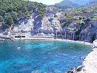
The far-flung bay of Port des Canonge, with its tiny gravel beaches, comes alive only at weekends, when the local fishermen set their boats to the water.