Geography of Cape Verde
The Cape Verde Islands are located in the mid-Atlantic Ocean some 450 km (280 mi) off the west coast of the continent of Africa.
[1] The landscape varies from dry plains to high active volcanoes with cliffs rising steeply from the ocean.
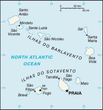
The archipelago consists of ten islands and five islets, divided into the windward (Barlavento) and leeward (Sotavento) groups.
[3] Three islands – Sal, Boa Vista, and Maio – generally are level and lack natural water supplies.
[1] Mountains higher than 1,280 metres (4,199 ft) are found on Santiago, Fogo, Santo Antão, and São Nicolau.
[1] Natural resources:Salt, basalt rock, limestone, kaolin, fish, clay, gypsum[5] Cabo Verde shares maritime boundaries with Mauritania and Senegal.
Cabo Verde has signed treaties with Senegal and Mauritania delimiting the specific boundaries.
[1] During the winter, storms blowing from the Sahara sometimes cloud the sky; however, sunny days are the norm year round.
The current north of the Canaries, has a cooling effect on the islands of Cabo Verde, making the air temperature more bearable than it would expect in any case at this latitude.
Conversely, the islands do not receive the upwellings (cold streams) that affect the West African coast, so the air temperature is cooler than in Senegal, but the sea is actually warmer, because the orographic relief of some islands, such as Sao Miguel with steep mountains, cover it with rich woods and luxuriant vegetation where the humid air condenses and soak the plants, rocks, soil, logs, and moss.
A Cape Verde type hurricane is formed in the area south of the islands, near Sao Miguel, after a tropical wave on the African continent during the rainy season.
Appear mostly occupying favorable areas named geographically Umbrias, this is north hillsides or slopes of the mountainous areas that are oriented behind the sun, because the islands are in the Northern Hemisphere, between 600 and 1,500 meters, thus benefiting from the humidity provided by the trade winds to form such a sea of clouds.
At first, the islands of Cabo Verde housed an extensive savanna and dry forest cover, but mostly it was removed to convert to agricultural land, which, together with the arid climate and rugged terrain, has led to a soil erosion and desertification widespread.
Today much of the forest cover comprises relatively immature agroforestry plantations, in which are used non-native species such as Prosopis juliflora, Leucaena leucocephala and Jatropha curcas.
These islands were covered with savanna on the plains and arid shrubland on the mountainsides, but after over 500 years of human habitation (after Portuguese colonisation) nearly all the original vegetation has been cleared in favour of widespread agriculture including the grazing of goats, sheep and cattle and the planting of imported crop species.
There are some remaining patches of dry forest high on steep mountainside including a number of endemic plant species, but these are inaccessible and hard to study.
However, most vegetation has now been converted to agriculture and forest fragments are now restricted to areas where cultivation is not possible, such as mountain peaks and steep slopes.
Santiago Island holds the only breeding site of the endemic and critically endangered Bourne's heron.