Bastia
[9] During the Roman Empire, the site of Cardo with the north-eastern district of the current commune of Bastia and Pietrabugno formed a Pieve: the oldest known administrative division.
Shortly afterwards, considering the great expense and little profit in Corsica, the Republic decided to withdraw and no longer intervene in the affairs of the island.
The five partners were: Leonello Lomellino, Giovanni da Balagnera, Aluigi Tortorino, Andreolo Ficone, and Cristoforo Maruffo.
[12] After an expedition to Cinarca followed by a short period of peace, Leonello Lomellino returned as governor and to gain an advantage over the Count Arrigo della Rocca with whom he would have to fight, he began by fortifying Aléria. "
Then Count Arrigo and his allies once again crossed the mountains and made incursions against Cap Corse: having met no resistance, they went to besiege Aléria which capitulated after four months.
[12] [Note 2] – Daniel Istria – Powers and fortifications in northern Corsica 11th – 14th Century p. 145 According to Giovanni della Grossa, the "seigneurialisation" of Loreto would have been, as with Genoese families of the Cape, usurping the County title acquired during the "people's government".
After raiding the castles of Nebbio and Pureto in the Ostriconi, he went on to the conquest of the pieve of Orto, which was then under the control of Bagnaia, and he built two new fortifications: Montebello and Petra di Bugno.
These were intended not only to dominate and control the northern part of Bagnaia, whose Cerlino Lake had a certain economic interest, but probably also to neutralise Porto Cardo, which occupied a strategic military position as well as having businesses.
The agreements between Giovanninello and the commune of Genoa in 1289 demonstrated the importance of this baronial control of land routes and anchorages, a major source of revenue and a guarantee of the security of the territory.
[13] Before the occupation of Corsica by the Genoese there were several communities of the pieve of Orto: Soverta, La Vetrice, Belgodere, Astima, and Le Corbaia.
Created by the Genoese patrician Leonello Lomellini in 1353 to liaise with Genoa, the city originated on the roack where a tower was built (a bastiglia, hence its name) and, a hundred years later, was surrounded by walls.
In 1794, during a war with Revolutionary France, British troops under Admiral Nelson and Lieutenant-General David Dundas briefly captured Bastia.
Azure, a fortress Argent, turreted, masoned, windows, and port of Sable on a terrace in base Vert.
Located in the North-East of Corsica at the base of the Cap Corse, between the sea and the mountain, Bastia is the principal port of the island.
The city is located on the Eastern side of the "Serra di Pignu", a 960 m (3,150 ft) mountain (see photo opposite).
In fact, many cafés, bars and restaurants have moved to its docks to which access is granted by the city for pedestrians only during summer evenings.
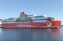
It is even more so during the summer when ferry arrivals and departures of thousands of passengers and cars can sometimes cause long traffic jams along the north–south axis, the national road RN193.
Just north of the commercial port, the Toga marina, named after a city neighborhood, is a harbor for leisure boating activities like sailing and yachting.
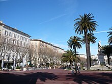
[citation needed] Nowadays, the city centre is mainly composed of the "citadelle", the stronghold, also called Terra-Nova, with the Genoese Governors' Palace, the old port and port quarter and the market plaza, and finally the ensemble of buildings along the "Boulevard Paoli", the main commercial street of the city, which lies from the Justice Court to the Avenue Maréchal Sebastiani.
The allochhtons are mainly in the area of lustrous schists and ophiolites corresponding to the eastern relief (Cap Corse and Castagniccia)".
The commune lies on the eastern flank of the "Serra di Pignu" a mountain which rises to 960 m above sea level.
This pronounced relief largely explains the development of the city on a coastal strip of about 1.5 km in width which is a very limited proportion of the 19.38 km2 of the whole commune.
There are also 7 other Bastia rail stops for suburban services to Casamozza: Lupino, Rivoli, Bassanese, Arinella, Montesoro, Sole-Meo, Erbajolo.
There is a clear dominance by Corsica Ferries: The Bastia – Poretta Airport is located 16 km south of the city in the commune of Lucciana.
It serves several French airports including Paris-Orly, Paris-Charles de Gaulle, Marseille-Provence, Nice-Côte d'Azur, and Lyon-Saint-Exupery.
Today the city centre consists mainly of the citadel (also called Terra Nova), the Palace of the Governors, the Old Port with its surrounding neighbourhood and the market place, and finally all the buildings along the Paoli Boulevard – the main commercial street of the city which stretches from the courthouse to the Avenue Maréchal Sebastiani.