Campbell Glacier
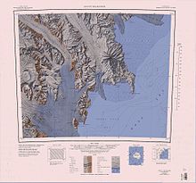
Campbell Glacier (74°25′S 164°22′E / 74.417°S 164.367°E / -74.417; 164.367) is a glacier, about 60 nautical miles (110 km; 69 mi) long, originating near the south end of Mesa Range and draining southeast between the Deep Freeze Range and Mount Melbourne to discharge into north Terra Nova Bay in Victoria Land, Antarctica.
[1] Campbell Glacier forms in the Southern Cross Mountains to the south of Gair Mesa and Suture Bench.
[3] The lower end of the glacier was observed by the Northern Party, led by Lieutenant Victor Campbell, Royal Navy, of the British Antarctic Expedition, 1910–13.
The extent of the glacier and its discharge into north Terra Nova Bay, rather than the Nansen Ice Sheet, was determined by United States and New Zealand survey parties to the area in 1961–62 and 1962–63.
Observed by the Northern Party of the New Zealand Geological Survey Antarctic Expedition (NZGSAE), 1965–66, which named it after the mythical river Styx.
Named by the northern party of NZGSAE, 1962-63, for Denys Rainey, cartographer, who assisted this and other New Zealand Antarctic expeditions with their mapping problems.
Named by the northern party of NZGSAE, 1962-63, because the geologist was said to have "recoiled in disgust" on finding little of geological interest there and not what he expected.
Named by US-ACAN for Lieutenant John L. Archambault, United States Navy, medical officer at McMurdo Station, 1967.
A sharp pointed nunatak rising above the ice at the lower end of Campbell Glacier, 5 nautical miles (9.3 km; 5.8 mi) ESE of Mount Dickason.
A prominent nunatak standing at the east side of the terminus of Campbell Glacier on the north shore of Terra Nova Bay.
[14] This article incorporates public domain material from websites or documents of the United States Geological Survey.