Bath and North East Somerset
Bath and North East Somerset covers an area of 136 square miles (352 km2), of which two thirds is green belt.
The city of Bath is the principal settlement in the district, but B&NES also covers Keynsham, Midsomer Norton, Radstock, Westfield, Saltford and the Chew Valley.
The history of human habitation is long but expanded massively during Roman times, and played significant roles in the Saxon era and English Civil War.
Industry developed from a largely agricultural basis to include coal mining with the coming of canals and railways.
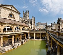
Bath developed as a spa resort in Georgian times and remains a major cultural tourism centre having gained World Heritage City status.
The age of the henge monument at Stanton Drew stone circles is unknown, but is believed to be from the Neolithic period,[4] as is the chambered tomb known as Stoney Littleton Long Barrow.
According to the Anglo-Saxon Chronicle, the Saxon Cenwalh achieved a breakthrough against the British Celtic tribes, with victories at Bradford-on-Avon (in the Avon Gap in the Wansdyke) in 652 AD.
[21] In the ninth century the old Roman street pattern had been lost and it had become a royal possession, with King Alfred laying out the town afresh, leaving its south-eastern quadrant as the abbey precinct.
[23] King William Rufus granted the city to a royal physician, John of Tours, who became Bishop of Wells and Abbot of Bath in 1088.
[29] Keynsham, said to be named after Saint Keyne, developed into a medieval market town, its growth prompted by the foundation of an influential and prosperous abbey, founded by the Victorine order of Augustinian monks around 1170.
[31] In 1668 Thomas Guidott, who had been a student of chemistry and medicine at Wadham College, Oxford, moved to Bath and set up practice.
This brought the health-giving properties of the hot mineral waters to the attention of the country and soon the aristocracy started to arrive to partake in them.
[34] The creamy gold of Bath stone further unified the city, much of it obtained from the limestone Combe Down and Bathampton Down Mines, which were owned by Ralph Allen (1694–1764).
[35] Allen, in order to advertise the quality of his quarried limestone, commissioned the elder John Wood to build him a country house on his Prior Park estate between the city and the mines.
The three raids formed part of the Luftwaffe campaign popularly known as the Baedeker Blitz; over 400 people were killed, and more than 19,000 buildings were damaged or destroyed.
[39] Houses in the Royal Crescent, Circus and Paragon were burnt out along with the Assembly Rooms, while the south side of Queen Square was destroyed.
Bath and North East Somerset covers an area of 136 square miles (352 km2),[41] of which two thirds is green belt.
The city of Bath is the principal settlement in the district, but B&NES also covers Keynsham, Midsomer Norton, Radstock and the Chew Valley.
The lake is a prominent landscape feature of the valley, a focus for recreation, and is internationally recognised for its nature conservation interest, because of the bird species, plants and insects.
Download coordinates as: Following a successful petition, a referendum was held on 10 March 2016 proposing a directly elected mayor for Bath and North East Somerset.
The fifteen electoral wards of Bath are: Bathwick, Combe Down, Kingsmead, Lambridge, Lansdown, Moorlands, Newbridge, Odd Down, Oldfield Park, Southdown, Twerton, Walcot, Westmoreland, Weston and Widcombe & Lyncombe.
According to the same statistics, the district is overwhelmingly populated by people of a white ethnic background at 97.2% – significantly higher than the national average of 90.9%.
Other non-white ethnic groups in the district, in order of population size, are multiracial at 1%, Asian at 0.5% and black at 0.5% (the national averages are 1.3%, 4.6% and 2.1%, respectively).
[110] The major towns and villages in the district are: Bath is approximately 12 miles (19 km) south-east of the larger city and port of Bristol, to which it is linked by the A4 road, and is a similar distance south of the M4 motorway.
Bath is served by the Bath Spa railway station (designed by Isambard Kingdom Brunel), which has regular connections to London Paddington, Bristol Temple Meads, Cardiff Central, Swansea, Exeter St Davids, Plymouth and Penzance (see Great Western Main Line), and also Westbury, Warminster, Frome, Salisbury, Southampton Central, Portsmouth Harbour and Brighton (see Wessex Main Line).
There are suburban stations on the main line at Oldfield Park and Keynsham which have a limited commuter service to Bristol.
Green Park station was once operated by the Somerset & Dorset Joint Railway, whose line (always steam driven) climbed over the Mendip Hills and served many towns and villages on its 71-mile (114 km) run to Bournemouth; this example of an English rural line was closed by the Beeching cuts in March 1966, with few remaining signs of its existence, but its Bath station building survives and now houses a number of shops.
The 2004 Bristol/Bath to South Coast Study[116] was commissioned as a result of the de-trunking in 1999 of the A36/A46 trunk road network from Bath to Southampton.
[117] Local radio stations are: State-funded schools are organised within the district of Bath and North East Somerset.
is the major football team in Bath city but there are also clubs in the surrounding areas such as; Paulton Rovers F. C., Bishop Sutton A.F.C., Radstock Town F.C.