Batham Gate
Hunter suggested the Long Causeway at Redmires as the route and it was shown as such on Ordnance Survey maps, but this is now known to be a medieval packhorse saltway.
The Roman road then descended Stanage Edge half a mile north-west of the present route, on a narrow and steeper terrace.
The feature, which extends through Barber Fields, is 20m wide and filled to a depth of 5m with rubble and has a metalled surface.
[5] A section of Batham Gate Road east of Peak Forest is a protected Scheduled Monument.
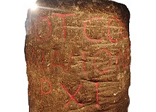
The inscription is ‘TRIB POT COS II P P A NAVIONE M P XI’ which means ‘With the tribune's power, twice consul, father of this country.