Battle of Arawe
Initial Allied goals for the landing at Arawe included securing a base for American PT boats and diverting Japanese forces away from Cape Gloucester.
While some have argued that the landing served as a useful diversion ahead of the Cape Gloucester operation, others believe that the entire campaign in western New Britain was unnecessary and that the force employed at Arawe could have been better used elsewhere.
From August 1942, U.S. and Australian forces conducted a series of offensives in New Guinea and the Solomon Islands, with the goals of eliminating Japanese positions in the region and establishing air bases close to Rabaul.
During the next five months, Australian and U.S. forces under the overall command of General Douglas MacArthur advanced along the north coast of eastern New Guinea, capturing the town of Lae and the Huon Peninsula.
The Gasmata operation was cancelled in early November in response to the concerns raised by Kenney and the Navy as well as intelligence reports that the Japanese had reinforced their garrison there.
[15] This operation had three goals: to divert Japanese attention from Cape Gloucester, to provide a base for PT boats, and to establish a defensive perimeter and make contact with the Marines once they landed.
[16] It was intended that PT boats operating from Arawe would disrupt Japanese barge traffic along the southern shore of New Britain and protect the Allied naval forces at Cape Gloucester from attack.
One troop was to capture Pitoe Island to the peninsula's south, as it was believed that the Japanese had established a radio station and a defensive position there which commanded the entrance to Arawe Harbor.
[33] Australian coastwatchers stationed on New Britain were reinforced during September and October 1943 to provide warning of air attacks from Rabaul bound for the Allied landing sites and to report on Japanese barge and troop movements.
[41] The Allies possessed little intelligence on western New Britain's terrain and the locations of Japanese forces, so they flew extensive air photography sorties over the region, and small ground patrols were landed from PT boats.
[48] A full-scale rehearsal of the landing was held at the island on 8 December; this revealed problems with coordinating the waves of boats and demonstrated that some of the force's officers were insufficiently trained in amphibious warfare.
[32][51] Shortly after the assault convoy arrived off Arawe, Carter Hall launched LVT amphibious tractors and Westralia lowered landing craft, both operated by specialized Marine and U.S. Army units.
The high speed transports carrying "A" and "B" Troops of the 112th Cavalry Regiment's 1st Squadron closed to within 1,000 yd (910 m) of Umtingalu and Pilelo Island respectively, and unloaded the soldiers into rubber boats.
[54] After disembarking from their boats, the cavalrymen advanced east and came under fire from a small Japanese force stationed in two caves near the village of Winguru on the island's north coast.
[41] The two Japanese Army companies that had been stationed at Arawe withdrew to the northeast and took up positions at Didmop on the Pulie River about 8 mi (13 km) from the MLR; the naval unit defending Umtingalu retreated inland in a state of disarray.
[66] However, the Allied air forces were able to mount a successful defense of the Arawe area as the coastwatcher parties in New Britain provided 30 to 60 minutes warning of most incoming raids.
[66] On 20 February, the Japanese air units at Rabaul and Kavieng were permanently withdrawn to Truk, ending any significant aerial threat to Allied forces in New Britain from the IJN.
A reserve defensive line was also established closer to Cape Merkus, and patrols were conducted each day along the shores of the peninsula in search of Japanese personnel attempting to infiltrate the Task Force's rear area.
The 1st Battalion, 141st Infantry Regiment, stationed at Cape Bushing on the south coast of New Britain about 40 mi (64 km) east of Arawe, was also directed to move by sea to counter the Allied invasion.
The battalion took eight days to cover the 7 mi (11 km) between Omoi and Didmop as it became lost on several occasions while travelling through trackless jungle and paused whenever contact with American forces seemed likely.
Cunningham had been ordered to gather intelligence on Japanese forces in western New Britain, and on 17 December he dispatched a patrol of cavalrymen in two LCVPs (Landing Craft, Vehicle, Personnel) to the west of Arawe to investigate the Itni River area.
These landing craft encountered seven Japanese barges carrying part of the 1st Battalion, 141st Infantry Regiment near Cape Peiho, 20 mi (32 km) west of Arawe, on 18 December.
[79] Cunningham believed that a large Japanese force was heading for the beachhead and contacted Krueger on 24 December to request that the 2nd Battalion of the 158th Infantry Regiment be dispatched to reinforce his command.
[83] The 1st Battalion, 141st Infantry Regiment arrived in the Arawe area on the afternoon of 29 December and conducted several small and unsuccessful attacks in early January before taking up positions about 400–500 yd (370–460 m) north of the American MLR.
[84] These American operations were conducted on a limited scale as Cunningham and the 112th Cavalry Regiment's other senior officers believed that the unit had already achieved the goals of the landing at Arawe and did not want to incur unnecessary casualties.
The Marine tanks and two companies of the 158th Infantry Regiment subsequently practiced tank-infantry cooperation from 13 to 15 January; during this period the 112th Cavalry continued to conduct patrols into Japanese-held areas.
The Americans did not detect this withdrawal until 27 February, when an attack conducted by the 2nd Squadron, 112th Cavalry and the Marine tank company to clear the Arawe area of Japanese encountered no opposition.
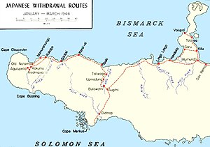
[96] Komori fell behind his unit and was killed on 9 April near San Remo on New Britain's north coast when he, his executive officer, and two enlisted men they were travelling with were ambushed by a patrol from the 2nd Battalion, 5th Marines, which had landed around Volupai and captured Talasea on the Willaumez Peninsula in early March.
The official history of the USMC in World War II stated that the presence of two experienced Japanese battalions at Arawe made the 1st Marine Division's task at Cape Gloucester easier.
[66] The U.S. Army's official history concluded that in retrospect the landings at Arawe and Cape Gloucester "were probably not essential to the reduction of Rabaul or the approach to the Philippines", though the offensive in western New Britain had some benefits and was not "excessively high in casualties".