Batu Pahat District
It lies southeast of Muar, southwest of Kluang, northwest of Pontian, south of Segamat and Tangkak District.
In around 1456, the Siamese army, led by Admiral Awi Di Chu, camped in Batu Pahat before attacking Malacca.
[4] Legend has it that the invading Siamese troops were chiselling rocks at a rocky spot in the coastal village of Kampung Minyak Beku, in hope to get fresh water during their retreat from the Melaka troops, led by Tun Perak, the famous Bendahara (Prime Minister) of the Malacca Sultanate.
Another possible explanation for the origin of the name is the fortress ("A Famosa") built by the Portuguese after capturing Melaka, which was made from granite rocks taken from the mouth of Sungai Batu Pahat.
[citation needed] Renowned for its salted fish in the past, Batu Pahat was formerly known as Bandar Penggaram, which means "town of salt-makers".
[5] Batu Pahat was the location of the headquarters for the Fiji Infantry Regiment, serving as part of the Commonwealth forces during the Malayan Emergency, from 1952 to 1956.
Currently, the newly refurbished town square is popular with locals on weekend nights and also provides as a venue for many public festive celebrations.
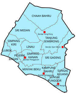
The district's 525 gazetted villages (kampung-kampung) and village-clusters (kampung rangkaian) were annexed to their bigger immediate neighbours into mukims for the purpose of administration.
[8] The district (daerah) is divided into fourteen mukims,[9][10] each designated with a number (Mukim 1 to 12, 17, 18): Growth in small and medium industries such as textiles, garments and electronics helped to boost development, and Batu Pahat was upgraded to town status (Majlis Perbandaran) in 2001, alongside Muar, Kluang and Skudai.
The Lim Sz Chong Su Tian Hou Temple (峇株吧辖林氏宗祠天后宫) was established in 1912 and is located in the downtown.
[13] Local "pasar malam" or night markets are held in residential areas with petty traders setting up stalls and selling a variety of food and daily necessities at bargain prices.