Beagle Channel cartography since 1881
The Beagle Channel Arbitration Court reviewed in-depth the cartography of the zone and stated that:[1]: §163 Finally, the Court wishes to stress again that its conclusion to the effect that the [Picton, Nueva and Lennox Islands] group is Chilean according to the 1881 Treaty has been reached on the basis of its interpretation of the Treaty, especially as set forth in paragraphs 55–111 above, and independently of the cartography of the case which has been taken account of only for purposes of confirmation or corroboration.
The same applies in respect of the particular maps discussed in, and from, paragraph 119 onwards.There was no agreement about the sovereignty over Patagonia and archipelago of Tierra del Fuego before the Boundary treaty of 1881 between Chile and Argentina.
The British Minister sent it to his Government with the comment that the dark shaded area "comprising the Strait of Magellan, half of Tierra del Fuego and all the southern islands, represent was actually has been ceded to Chile by the recent Treaty.
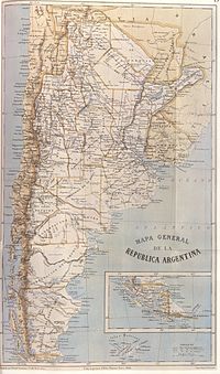
It was ordered to be drawn up by the then Argentine Minister of the Interior, Bernardo de Irigoyen (who had previously been Minister of Foreign Affairs in which capacity he signed the Boundary Treaty of 1881) for inclusion in an official publication issued by the Director of the National Statistics Office, Dr. Francisco Latzina, in 1883 under the title "The Argentine Republic as a field for European Immigration"[1]: §126–128 (under Latzina map of 1882).
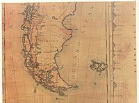
This official map of Chile, partially reproduced here, "was drawn up on the orders of the Chilean Government for use in primary schools in the Republic and with a view to the most recent data" by Alejandro Bertrand in 1884.
As may be observed, the international boundary is traced along the centre of the Beagle Channel, showing Picton, Nueva and Lennox and all the other islands and islets extending southwards as far as Cape Horn as being under Chilean sovereignty.
"This work obtained the 'Rivadavia Award' [Gran Premio Bernardino Rivadavia] of the 'Argentine Geographic Institute' and a large number of copies of it were ordered by the Argentine authorities for distribution in Europe and elsewhere.
"[1]: §157a The jury was conformed by Estanislao Zeballos, Bartolomé Mitre, Julio Argentino Roca, Domingo Faustino Sarmiento, Guillermo Rawson and Lucio V.
[2] In the extreme southern region, the international boundary is traced along the centre of the Beagle Channel and stretches to the south of the Isla de los Estados.
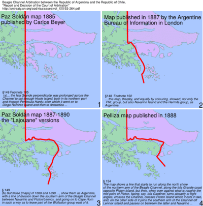
This and other turnarounds (see below) of Paz Soldáns Interpretation of the 1881 Boundary Treaty caused the Arbitral Court to discard his maps from the documentary evidence.
In the southern region the international boundary is shown traced through the centre of the Beagle channel, continuing beyond the eastern mouth of the Channel, indicating Picton, Nueva and Lennox Islands and all other islands and islets extending southward as far as Cape Horn as being under Chilean sovereignty In the course of time became noticeable in Argentina a position that worked continuously towards a new interpretation of the Boundary Treaty.
For example, in 1885 appeared a map of Mariano Paz Soldán that continued the perpendicular in the Tierra del Fuego Island forth to the Antarctic, "a fanciful line unrelated to the Treaty basis of division" as stated by the Court of Arbitration.
In order to decide the validity of a map the court used following criterion for exclusion: Footnote 102 This in two respects: (i) since under the first part of Article III of the Treaty, the perpendicular in the Isla Grande of Tierra del Fuego, from Cape Espíritu Santo to the Beagle Channel, was deliberately stopped there, a map showing a line of division which, by prolonging the perpendicular, crossed the Channel, and proceeded southward through the Murray Sound and past the Wollaston group, could not possibly represent the division contemplated by the Treaty; (ii) this map, thereby, and equally by colouring, showed, not only the PNL group, but also Navarino Island and the Hermite group, as Argentine.
As may be seen from the map, the boundary line deviates from the Beagle Channel towards Picton and Richmond Passages to end up between Lennox and Nueva Islands.
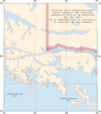
The image at the left is a section of a map published by the Instituto Geográfico Militar de Argentina in 1945 in scale 1:2.500.000 with a new "Canal Moat".
He alleged that the channel did not reach the Cape San Pío but at the "Punta Navarro" flows to the south through the Navarino and Picton islands.
[3]: 69 1899 ordered the Argentine navy the ship ARA Almirante Brown (1880) under the command of Captain Juan P. Saenz Valiente on a hydrographic survey of the Beagle channel.
The Argentine military regions are distinguished by different colours, all territories located south of the Beagle Channel as far as Cape Horn have been omitted and thus understood to be under Chilean sovereignty.
[6] The international boundary shown in the Beagle Channel zone corresponds to the Argentine claim in the area which the arbitral decision of 18 April 1977 put a definitive end.
The reason could be that in 1938 the Argentine delegation to the Hydrographic Conference in Oslo tried to define the meridian 68° 43'W (through the Chilean Diego Ramírez Islands) as limit between the Pacific and Atlantic oceans.
[3]: 97 During the Proceso de Reorganización Nacional (1976–1983) and based on concepts of territorial nationalism and geopolitics Argentine geography sustained the possession of the islands as a "vital issue" and called on to a "march to the south" in order to follow some kind of Argentine Manifest Destiny: Classical geopolitics [thoughts] of the late nineteenth century, the crudest biological metaphors of geographic determinism, militarism, the principles of the Doctrina de la Seguridad Nacional and the corporative nationalism can be noted, concealed, subtly or in plain language in the manifests, conferences and statements of the geographersThe Beagle conflict, the Falklands dispute and the question of the use of the Rio de la Plata Basin became through the works of the geographic topics of popular interests and opinion.