Beauregard Castle, Chippis
In 1387, the castle was damaged by the soldiers of Amadeus VII in reprisal for an uprising of the Raron against the Bishop of Sion, Edward of Savoy.
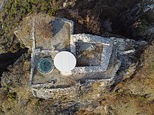
The castle had a dwelling served by a spiral staircase, a tower and a circular cistern unique in Valais, all surrounded by an enclosure.
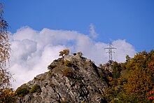
[3] Also known as "l'Imprenable" (in English "the Impregnable"), the castle's location overlooks a panorama of the Rhône valley and part of the Val d'Anniviers.
[2][4] The origin of the Beauregard Castle is uncertain; it was only mentioned twice in the regional archives: on a deed of 1457 under the name "bel regard" and on a map of 1545 under the name "Perigard".
[8][10] On the death of the latter, who had no sons, the estate of the Val d'Anniviers first went to Aymon de Challant, Beatrice's first father-in-law, and was then bought by Peter of Raron who was then Count of Sierre, for 1,700 florins.
It may have been used to defend either the entrance to the Val d'Anniviers or the road on the left bank of the Rhône, but it is also possible that it served as an observation and communication post by means of fires or as a refuge of last resort for its owners.
[5] In the 1380s, Peter of Raron led a revolt movement against the new Bishop of Sion, Edward of Savoy who had displeased the people of Valais because of his Savoyard origins, his family being seen as too powerful.
Peter of Raron complied, however, as Edward of Savoy could not move without a Savoyard personal guard, he decided to resign two years later.
Beauregard Castle was finally taken and Peter's sons, Petermann and Heinzmann, were imprisoned and hanged on the Grand-Pont in Sion.
[19] He also questioned a 15th-century construction, preferring a 12th-century estimate and stating: "[In the 15th century], we were trying ... to get closer to the roads and avoid the inconveniences due to the lack of supplies".
In 2005, Bernard de Preux, a member of the Swiss Heritage Society, proposed the launch of an archaeological investigation in order to learn more about the importance of the site.
Three years later, Swiss Heritage and the communes of Chippis and Sierre set up the Beauregard Castle Foundation to raise funds to carry out the excavation work.
[1][21] The first field survey was carried out in 2008 and, once the cantonal authorisations had been obtained, the Beauregard site was cleaned up and the top of the hill was lowered by 9 metres (30 ft).
Led by Alessandra Antonini, the archaeological excavations took place from 2009 to 2011 and uncovered a large part of the castle's ruins.
This wall also served as the first gate controlling access to the footbridge, similar to the western fortifications of Tourbillon Castle, and was between 3 and 4 metres (9.8 and 13.1 ft) high.
The central part of the bridge rested on wooden uprights set into the rock of the moat, while its deck could be dismantled in the event of an attack.
Further notches at the foot of the southern facade of the spur show that there was a first staircase leading to a landing, followed by four further steps ending at the main gate of the castle.
This channel is responsible for discharging the surplus water to the east of the castle; it is possible that a spillway to the west existed, but this part of the cistern has collapsed.
The eastern hall was probably similar in architecture to the western one, with the exception of its south-western corner, which was more massive as it straddled the level of the upper terrace and the cistern.
It is possible that its use was reserved for the garrison, as the latrines of the lords were probably on the second floor of the main building, as is the case in the castles of Saxon or Saillon.