Beijing city fortifications
[1] Xu Da decided that Dadu's fortification system was too large to defend during a siege, so he ordered the city's northern walls rebuilt 2.8 kilometres (1.7 miles) to the south of the original location.
Extensive expansion and reconstruction work would be needed to meet the defence requirements of the new capital for it to withstand the sporadic Mongol incursions from the north.
The newly expanded city wall and moat system was 45 lis (22.5 kilometres (14.0 mi)) around the perimeter, providing formidable defence.
In 1901 British troops tore down the eastern section of the Outer city walls at Yongdingmen to allow an extension of the railway eastwards to Zhengyangmen.
Here, British embassy and consulate staff could board trains to travel to the port city of Tientsin (now Tianjin) in the event of the need to retreat.
British troops also tore down the eastern section of the Outer city wall near Dongbianmen for the construction of the Beijing Dongbianmen-Tongzhou feeder railway.
Government-sponsored city planning studies showed that the remaining wall and moat structures were hindering traffic flow and were a barrier to expansion and development.
He recommended cutting more arches to accommodate new roads that would serve increased traffic needs, and suggested building a giant circum-city public park immediately outside the city walls and moats to beautify the environment.
Pro-keep supporters included Redologist Yu Pingbo, then Department of Culture Vice Minister Zheng Zhenduo and many Soviet city planners then in the country.
Since demolishing houses and relocating people would have been such a great undertaking, the decision was made to build the metro line where the city walls and moats were located.
After construction began on the metro system, troops were brought in to help with the demolition work to increase the speed and efficiency of the process.
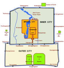
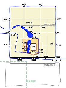
The second stage began at Beijing railway station in the southeast corner of the Inner City and passed through the sites of Jianguomen, Andingmen, Xizhimen, and Fuxingmen.
Another section from Chongwenmen to the guard tower at the southeast corner of the Inner city was spared, because the metro line veered towards the Beijing railway station.
Beginning in 1972, in order to pave the 2nd Ring Road above the Metro, and to serve high-rise apartments and hotels in the Qianmen area, Beijing's eastern, southern, and western moats were covered and converted to sewers.
The city gates were closed at night and no one was allowed in or out unless special permission was given though one exception was the carts that continually brought spring water from Mount Yuquan.
[7] From the Yongzheng era (1722–1735) onwards, the Eight Banner guard troops in charge of protecting the imperial leisure parks were camped in the area around the Old Summer Palace and Fragrant Hills.
Russian and Japanese forces attempted several times to use nitrocellulose to blow a gap in the wall at Dongzhimen and Chaoyangmen, but failed because the soldiers could not get close enough to light the fuse without being shot.
The other Inner city watchtowers had exterior designs similar to that of Qianmen, with multi-eaved Xieshanding-style gate towers in the front and a series of five rooms in the back.
The Empress Dowager Cixi's "cosmetic spending" and the early Republican China president's annual salary came directly from taxes levied at this gate.
This was where the rammed earth walls of the Yuan city of Dadu had been located before being abandoned in the closing years of the Hongwu era (1368–1398) during the early Ming dynasty.
However, due to successive invasions from the Mongols and Manchus, soldiers were called away to the northern frontiers to defend the Great Wall, and thus few could be spared for construction.
During the Boxer Rebellion, on 11 June, the secretary of the Japanese legation, Sugiyama Akira (杉山 彬), was attacked and killed by the Muslim soldiers of General Dong Fuxiang near Yongdingmen, who were guarding the southern part of the Beijing walled city.
Because it was heavily used by new arrivals entering the city from the southern Chinese provinces, the Qianlong Emperor decided to make the gate more impressive and majestic.
The wall had two rows of roof tiles glazed in the imperial yellow colour set on a triangular base 0.84 metres tall.
The eastern route turned 90 degrees south at the northeastern corner guard tower and converged with the city's southern moat system to the northwest of Dongbianmen.
From the Yongle era (1402–1424) until the mid-Qing dynasty (1644–1912), the eastern sections of the southern moat system were used as canals for the transportation of staple foods entering the city.
Commoners could board boats at the eastern moat system, travel southwards to leave the city at Dongbianmen, and go down the Tonghui River, which leads to the rural areas of Tongzhou.
He wrote: "The gates may be called the mouths of the city; they are the openings through which this huge walled-in body of half a million or more organisms breathes and speaks.
And that which passes in and out is not simply a mass of vehicles, animals, and human beings, but thoughts and desires, hopes and despairs, death and new life in the shape of marriage- and funeral-processions.
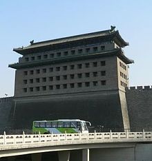
Restoration of the section of the city wall near the Beijing Ancient Observatory and its enemy sight tower are in the planning stages, as well as the barbican at Zhengyangmen.