Ben Nevis
Ben Nevis stands at the western end of the Grampian Mountains in the Highland region of Lochaber, close to the town of Fort William.
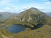
The 700-metre (2,300 ft) cliffs of the north face are among the highest in Scotland, providing classic scrambles and rock climbs of all difficulties for climbers and mountaineers.
Nibheis may preserve an earlier Pictish form, *Nebestis or *Nebesta, involving the Celtic root *neb, meaning 'clouds' (compare: Welsh nef ).,[7] thus 'Cloudy Mountain'.
[16] In addition to the main 1,345-metre (4,413 ft) summit, Ben Nevis has two subsidiary "tops" listed in Munro's Tables, both of which are called Càrn Dearg ("red hill").
Under ideal conditions, it can extend to over 190 kilometres (120 mi), including such mountains as the Torridon Hills, Morven in Caithness, Lochnagar, Ben Lomond, Barra Head and to Knocklayd in County Antrim, Northern Ireland.
Ben Nevis's elevation, maritime location and topography frequently lead to cool and cloudy weather conditions, which can pose a danger to ill-equipped walkers.
[37] Research has shown igneous rock from the Devonian period (around 400 million years ago) intrudes into the surrounding metamorphic schists; the intrusions take the form of a series of concentric ring dikes.
[38][39] The first recorded ascent of Ben Nevis was made on 17 August 1771[40] by James Robertson, an Edinburgh botanist, who was in the region to collect botanical specimens.
[42] The following year William MacGillivray, who was later to become a distinguished naturalist, reached the summit only to find "fragments of earthen and glass ware, chicken bones, corks, and bits of paper".
[28] In the summer of 1881, Clement Lindley Wragge climbed the mountain daily to make observations (earning him the nickname "Inclement Rag"), leading to the opening on 17 October 1883 of a permanent observatory run by the SMS.
[28] The opening of the path and the observatory made the ascent of the mountain increasingly popular, all the more so after the arrival of the West Highland Railway in Fort William in 1894.
[53] In 2000, the Ben Nevis Estate, comprising all of the south side of the mountain including the summit, was bought by the Scottish conservation charity the John Muir Trust.
It begins at Achintee on the east side of Glen Nevis about 2 km (1.2 mi) from Fort William town centre, at around 20 metres (66 feet) above sea level.
[61] A route popular with experienced hillwalkers starts at Torlundy, a few miles north-east of Fort William on the A82 road, and follows the path alongside the Allt a' Mhuilinn.
[63] In common with other approaches on this side of the mountain, it has the advantage of giving an extensive view of the cliffs of the north face, which are hidden from the Pony Track.
It was one of the first places in Scotland to receive the attention of serious mountaineers; a partial ascent and, the following day, a complete descent of Tower Ridge in early September 1892 is the earliest documented climbing expedition on Ben Nevis.
[71] Many seminal lines were recorded before the First World War by pioneering Scottish climbers like J. N. Collie, Willie Naismith, Harold Raeburn, and William and Jane Inglis Clark.
[50] The following years saw several improvements on Swan's record, but the first competitive race was held on 3 June 1898 under Scottish Amateur Athletic Association rules.
Ten competitors ran the course, which started at the Lochiel Arms Hotel in Banavie and was thus longer than the route from Fort William; the winner was 21-year-old Hugh Kennedy, a gamekeeper at Tor Castle, who finished (coincidentally with Swan's original run) in 2 hours 41 minutes.
[76] It starts and finishes at the Claggan Park football ground on the outskirts of Fort William, and is 14 kilometres (8.7 mi) long with 1,340 metres (4,400 ft) of ascent.
[77] Due to the seriousness of the mountain environment, entry is restricted to those who have completed three hill races, and runners must carry waterproofs, a hat, gloves and a whistle; anyone who has not reached the summit after two hours is turned back.
[79] In 2018 Jöttnar pro team member Tim Howell BASE jumped off Ben Nevis which was covered by BBC Scotland.
[81] Also in May 2019, a team of 12, led by Dundee artist Douglas Roulston carried a 1.5-metre (4.9-foot) tall statue of the DC Thomson character Oor Wullie to the top of the mountain.
The problem stems from the fact that the summit plateau is roughly kidney-shaped and surrounded by cliffs on three sides; the danger is particularly accentuated when the main path is obscured by snow.
Two precise compass bearings taken in succession are necessary to navigate from the summit cairn to the west flank, from where a descent can be made on the Pony Track in relative safety.
[92] In the late 1990s, Lochaber Mountain Rescue Team erected two posts on the summit plateau to assist walkers attempting the descent in foggy conditions.
[94] Subsequently, the John Muir Trust cleared a number of smaller informal cairns in 2016 which had been erected by visitors, which were seen as dangerous as they could confuse walkers using them for navigation.
[104] Ben Nevis was the name of a White Star Line packet ship which in 1854 carried the group of immigrants who were to become the Wends of Texas.
[107] Hung Fa Chai, a 489-metre (1,604-foot) hill in Northeast New Territories of Hong Kong was given the name Ben Nevis by British surveyors in 1901.
[108] Wee Ben Nevis was a character appearing in The Beano comic for a few years from 1974, drawn by Vic Neill,[109] in a feature described by Auberon Waugh as having "strong undertones of Scottish Nationalism by its untrue suggestion that Scotsmen have superhuman strength despite their diminutive stature".