Benin
The majority of its population lives on the southern coastline of the Bight of Benin, part of the Gulf of Guinea in the northernmost tropical portion of the Atlantic Ocean.
[20] The situation changed in the 17th and 18th centuries as the Kingdom of Dahomey, consisting mostly of Fon people, was founded on the Abomey plateau and began taking over areas along the coast.
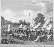
[24] Dahomey instituted an elite female soldier corps variously called Ahosi (the king's wives), Mino ("our mothers" in Fongbe) or the "Dahomean Amazons".
This emphasis on military preparation and achievement earned Dahomey the nickname of "Black Sparta", from European observers and 19th-century explorers such as Sir Richard Burton.
Court protocols which demanded that a portion of war captives from the kingdom's battles be decapitated, decreased the number of enslaved people exported from the area.
France sought to benefit from Dahomey and the region "appeared to lack the necessary agricultural or mineral resources for large-scale capitalist development".
As a result, France treated Dahomey as a sort of preserve in case future discoveries revealed resources worth developing.
[33][34] After 1960, there were coups and regime changes, with the figures of Hubert Maga, Sourou Migan Apithy, Justin Ahomadégbé, and Émile Derlin Zinsou dominating; the first three each represented a different area and ethnicity of the country.
[citation needed] On 7 May 1972, Maga ceded power to Ahomadégbé On 26 October 1972, Lt. Col. Mathieu Kérékou overthrew the ruling triumvirate, becoming president and stating that the country would not "burden itself by copying foreign ideology, and wants neither Capitalism, Communism, nor Socialism".
On 30 November 1974, he announced that the country was officially Marxist, under control of the Military Council of the Revolution (CMR), which nationalized the petroleum industry and banks.
Establishing relations with China, North Korea, and Libya, he put "nearly all" businesses and economic activities under state control, causing foreign investment in Benin to dry up.
[47] In the March 2016 presidential elections in which Boni Yayi was barred by the constitution from running for a third term, businessman Patrice Talon won the second round with 65.37% of the vote, defeating investment banker and former Prime Minister Lionel Zinsou.
[52] On 20 February 2022, President Patrice Talon inaugurated an exhibition with 26 pieces of sacred art returned to Benin by France, 129 years after they were looted by colonial forces.
These changes have drawn condemnation from international observers and led to the United States government partially terminating development assistance to the country.
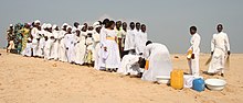
[65] About 42 African ethnic groups live in this country, including the Yoruba in the southeast (migrated from Nigeria in the 12th century); the Dendi in the north-central area (who came from Mali in the 16th century); the Bariba and the Fula in the northeast; the Betammaribe and the Somba in the Atakora Mountains; the Fon in the area around Abomey in the South Central and the Mina, Xueda, and Aja (who came from Togo) on the coast.
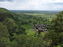
Behind the coast lies the Guinean forest-savanna mosaic-covered plateaus of southern Benin (altitude between 20 and 200 m (66 and 656 ft)), which are split by valleys running north to south along the Couffo, Zou, and Ouémé Rivers.
[91] Historically Benin has served as habitat for the endangered African wild dog, Lycaon pictus;[92] this canid is thought to have been locally extinct.
In 2017, Benin imported about $2.8 billion in goods such as rice, meat and poultry, alcoholic beverages, fuel plastic materials, specialized mining and excavating machinery, telecommunications equipment, passenger vehicles, and toiletries and cosmetics.
[98] In order to raise growth still further, Benin plans to attract more foreign investment, place more emphasis on tourism, facilitate the development of new food processing systems and agricultural products, and encourage new information and communication technology.
An "insufficient" electrical supply continues to "adversely affect" Benin's economic growth and the government has taken steps to increase domestic power production.
This has been updated and complemented by new texts on science and innovation (the year of adoption is between brackets):[78] Equally important are Benin's efforts to integrate science into existing policy documents: In 2015, Benin's priority areas for scientific research were: health, education, construction and building materials, transportation and trade, culture, tourism and handicrafts, cotton/textiles, food, energy and climate change.
[78] The University of Abomey-Calavi was selected by the World Bank in 2014 to participate in its Centres of Excellence project, owing to its expertise in applied mathematics.
In December 2014, 150 volunteer health professionals traveled to Guinea, Liberia and Sierra Leone from Benin, Côte d'Ivoire, Ghana, Mali, Niger, and Nigeria, as part of a joint initiative by the Economic Community of West African States (ECOWAS) and its specialized agency, the West African Health Organisation, to help combat the epidemic.
African leaders meeting in Equatorial Guinea failed to resolve the debate on establishing a common standard of measurement for the 10% target.
The Trans-West African Coastal Highway crosses Benin, connecting it to Nigeria to the east, and Togo, Ghana and Ivory Coast to the west.
Rail transport in Benin consists of 578 km (359 mi) of single track, 1,000 mm (3 ft 3+3⁄8 in) metre gauge railway.
Cadjehoun Airport, located at Cotonou, has direct international jet service to Accra, Niamey, Monrovia, Lagos, Ouagadougou, Lomé, and Douala, and other cities in Africa.
Post-independence, native folk music was combined with Ghanaian highlife, French cabaret, American rock, funk and soul, and Congolese rumba.
Beninese languages are "generally transcribed" with a separate letter for each speech sound (phoneme), rather than using diacritics as in French or digraphs as in English.
[citation needed][113][114] The major sports in Benin are association football, basketball, golf, cycling, baseball, softball, tennis and rugby union.