Berlin Stadtbahn
It runs from Ostbahnhof in the east to Charlottenburg in the west, connecting several of the most major sights of the German capital.
The line connects the city's Zoo, Bellevue Palace, snakes around the governmental district to the Berlin Hauptbahnhof and Friedrichstraße, crosses Museum Island[a], and moves on to Alexanderplatz (Fernsehturm) and beyond.
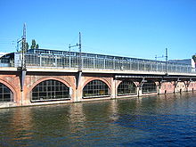
A further 2 kilometers (1.2 mi) of the line is situated on 64 bridges, that cross adjoining streets and (three times) the river Spree.
[4] The state's interest in the line was attributed to the military, which after the 1870-1871 Franco-Prussian War was of the opinion that the railway networks would hinder mobilisation when not properly interconnected.
Having taken similar projects in London and New York City into consideration, passenger traffic received priority over freight trains.
The traffic routing was not only influenced by the location of the already existing stations the line was supposed to connect, but also by land availability in the city centre.
One of the original drafts, which called for building the line along Leipziger Straße, had to be scrapped because of overly high land prices.
The moat of the 17th century Berlin Fortress was filled up between Hackescher Markt and Jannowitzbrücke stations and, since it was public land, was used for building the railway line.
By the end of the 19th century, however, most of these train runs had to terminate at their old destination stations again due to the increasing local traffic on the Stadtbahn.
In December 1930 the term S-Bahn and the symbol of a white S on a green circle were introduced for the city, ring and suburban services.
Because Joseph Stalin wanted to travel by train to the Potsdam Conference, the Stadtbahn was converted to the Russian 1,520 mm (4 ft 11+27⁄32 in) broad gauge in 1945.
The Stadtbahn was useful for the re-established S-Bahn, however, now with connections to places line Königs Wusterhausen, Strausberg, Staaken and Falkensee.
Regular quarrels erupted between the DR, the GDR government, the West Berlin Senate and the Allied occupation powers.
Despite problems, the Deutsche Reichsbahn made improvements to the line and reconstructed at great expense the Westkreuz railway station which had been built on swamp land.
Soon thereafter, talks with the GDR commenced regarding improvements of the Stadtbahn in West Berlin as well as the modernisation of the Zoologischer Garten station.
[11] The fall of the Berlin Wall and German reunification made for a sudden spike of importance for the Stadtbahn.
The viaduct sections were checked and strengthened, and the tracks were bedded in concrete to improve durability and comfort.
The realigned section consisted of two 450 m-long bridges spanning the station and the adjacent Humboldthafen port.
Until the summer of 2006, the Stadtbahn was the main thoroughfare for long-distance trains, which usually stopped at Zoologischer Garten and Ostbahnhof (which was renamed in 1998).
The remaining intercity trains on the Stadtbahn, mainly those heading toward Hanover and Cologne, now usually call at Hauptbahnhof and Ostbahnhof.
The attachment points of the thought to be much more durable solution had to be replaced quickly due to safety concerns.
[14] The S-Bahn tracks of the Stadtbahn currently carry the following routes (as of December 2020): The longer distance tracks carry Regionalbahn and Regional-Express routes RE1 (Magdeburg to Eisenhüttenstadt), RE2 (Rathenow to Cottbus), RE7 (Dessau to Wünsdorf-Waldstadt) and RB14 (Nauen to Berlin Schönefeld Airport).