Berwickshire
The low-lying part of Berwickshire between the Tweed and the Lammermuirs is known as "the Merse", from an old Scots word for a floodplain, and this name is sometimes extended to the county as a whole.
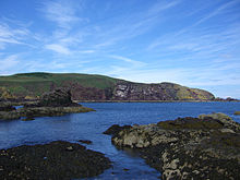
The terrain of Berwickshire is characterised by a series of low hills and agricultural land, with a number of small towns scattered throughout the county.
The Lammermuir Hills traverse the border with East Lothian; it is here that Meikle Says Law, the highest point in the county at 535 m (1,755 ft), can be found.
Between the late tenth and early eleventh centuries, the land between the rivers Forth and Tweed came under Scottish control.
The shire covered the town of Berwick plus a largely rural area to the north-west of it, and corresponded to the medieval province of Merse.
County Hall was built at Greenlaw in 1829 to serve as the courthouse and meeting place for the commissioners, replacing an earlier building on an adjoining site.
[10][11] Elected county councils were established in 1890 under the Local Government (Scotland) Act 1889, taking over most of the functions of the commissioners.
The county council subsequently established additional offices in various converted houses along Newtown Street.
[14][15] At the time of the county council's abolition in 1975, Berwickshire contained four burghs and three districts:[16] Berwickshire County Council was abolished in 1975 under the Local Government (Scotland) Act 1973, which reorganised local government across Scotland into upper-tier regions and lower-tier districts.
The coat of arms shows a bear chained to a wych tree, forming a pun on the name of the original county town of Berwick.
The A1 road runs roughly parallel to the railway and provides access to Edinburgh in the north and to the south Berwick-upon-Tweed, continuing on to Newcastle.