Bethel Island
(Source: California State Archives for Land Patent Certificate of Purchase for Swamp and Overflow Surveys Numbers 80, 81, 82, 83, 225, 226, 227 and 250).
East Contra Costa Historical Society has been made aware of these inaccuracies, however has not yet updated their website.
The second "L" was dropped by a rather pious postal commissioner that reportedly felt it would be ungodly to allow the new location to be called "Bet Hell", and took liberties to change it to "Bethel" (בית אל), meaning "House of God" in Hebrew.
Though it was common for the era to name the post office after the postmaster, and for the communities to assume the name of the post office, there are some references to the area as "Bethell" referring to the Sand Mound Ranch farm established by a coalition led by Franklin's older brother, Warren King Bethell, Nicholas Harris (Sheriff of San Jose) and James C. Smith.
This may not be a fair assessment of all, since some did make an honest attempt to reclaim the lands only to be forced out by changes in governmental policy and financial constraints.
The first applications for land patents for what is now Bethel Island, Jersey Island, Franks Tract and Webb Tract, were secured by early California pioneers (the patent number precedes the name, and the date of application follows): 80-H. L. Henderon (1859), 81-Jabez Hatch (1859), 82-Elijah Hook (1859), 83-Stephen C. Vaughn (1859), 221-Edward P. Paine (1865), 222-John F. Arnold (1865), 223-John P. Curtis (1865), 224-Jessa Cheney (1865), 225-William Nye (1865), 226-Stephen L. Piper (1865), 227-D. J.
Through the remainder of the 1860s and most of the 1870s, interest in several of these lands were traded or sold, passing to Cheney (who later partnered with Van W. Phillips), Hatch, Piper and Taylor.
There, he engaged in mining for a few months, then settled in Santa Clara County, buying 250 acres on Almaden Road.
Warren encouraged his younger brother, Franklin, to move West to assist in this new venture.
Newspaper records of the time show Franklin as a frequent occupant of several of the finer hotels in San Francisco, Sacramento, and Brentwood.
Ann went on to form a successful ranch in Almaden Valley and established the Bethell Block in downtown San Jose (site of the current Federal Building).
The portion of the land along the levee of Taylor Slough were held by James C. Smith stayed with his descendants until 1941.
Postal office did not want the name "Bet Hell" and dropped the additional "L" to make it "Bethel", like the Hebrew term בית אל beth el which translates to "House of God,"[10] Franklin's post office closed in 1902, however the name Bethel(l) was now officially tied to the locality.
[9] A one-lane wooden bridge was built in 1911, but was removed by order of the Army Corps of Engineers.
In the late 1930s a resort was created by Houston (Jack) Farrar and his wife Blanche (Ruby), with a recreational area for picnics and swimming.
Hunters, fishermen, and boaters began buying property after World War II.
[11] In 2019, construction began on Delta Coves, a development of 494 homes built around a man-made lagoon on top of a double levee.
"[8] According to the United States Census Bureau, the CDP has a total area of 5.1 square miles (13 km2), all of it land.
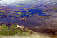
[9] The island is surrounded by Taylor, Piper, Dutch and Sandmound Sloughs, and protected by 11.5 miles (18.5 km) of earthen levees.
The state created Swamplands Districts #1, 102, 107 and 183 in 1894 to raise money for maintaining the levees in the California Delta.
[8] The Bethel Island Municipal Improvement District (BIMID) was created from RD 1619 in 1960, and provides some of the same functions as a city government.
BIMID has five directors who are elected for four-year terms by registered voters living on Bethel Island.
The BIMID property on Stone Road consists of the District offices, a meeting room and a small equipment yard.