Bidar district
Traditional tales refer to the surrounding region of Bidar district as "Viduranagara" and also as the place where Nala and Damayanthi met.
[4] The area was ruled by the Mauryas, Satavahanas, Rashtrakutas, Chalukyas, Kalachuris, Kakatiyas, Khaljis, Bahamanis, Baridshahis, Mughals and the Nizams of Hyderabad.
[5] Bidar district is well known for its different religions, castes and cultures due to its historical developments through the ages.
The regal capital was later moved to Manyakheta (Malkhed) in the present day Kalaburagi district by Amoghavarsha I.
Later, Bidar was ruled in succession by the vassals to Sevuna Yadavas of Devagiri, Kakatiyas of Warangal, Alauddin Khalji and Muhammad bin Tughluq.
The generals of Muhammad Bin Tughlaq who were nominated as viceroys of the newly conquered Deccan region broke up and formed the Bahmani Sultanate under Allauddin Hasan Gangu Bahman Shah.
The total geographical area of the district as per the provisional figures computed by the Survey of India is 5,451 km2 (2,105 sq mi), while the reporting area of the district for land-utilisation purposes, as worked out by the State Department of Survey Settlement and Land Records and local bodies, is 5,448 km2 (2,103 sq mi).
[5] The district extends from latitude 17.35'N to 18.25'N and from the longitudes 76.42'E to 77.39'E[7] which is located on the northern maidans of Karnataka which provides a mountainous treeless expansive plateau landscape.
The soils covering this region are black to deep brown in colour which are rich in humus and form some of the most valuable fertile lands in the country,[8]: 29 well suited for cultivating pulses.
The northern part of the district is characterized by expanses of level and treeless surface punctuated here and there by flat and undulating hillocks, black soils and basaltic rocks.
The top layers of the Deccan trap in parts of Bidar and Humnabad talukas are altered to reddish vesicular laterite, forming and extensive undulating plateau.
The surface of the plateau presents wide stretches of red plains, either waved over by light dry grasses alive with coveys of partridges and herds of deer, or mottled by every sort of cultivation for which artificial irrigation is not essential.
The laterite must everywhere be pierced nearly to the subjacent trap to reach the perennial springs, so that the wells in the vicinity of the edges of the tableland (maidan) are of extraordinary depth.
The stream-fed valleys and the tracts of mixed soil in the lowlands bear prodigally fruits and grains, sugarcanes and vines, and every variety of vegetable produce.
The temperature varies in the district between 20 °C and 42 °C The summer season in Bidar starts in the first week of March and lasts until mid-June.
It is the northernmost member of the Medicinal Plants Conservation Network established by the Karnataka forest department and the Foundation for Revitalization of Local Health Traditions (FRLHT) jointly.
The vegetation is the dry deciduous scrub type, with most of it being stunted due to harsh climatic and edaphic factors.
Common tree species in the drier parts are Albizzia amara, Madhuca latifolia, Buchnania lanzan, Butea frondosa, Ficus bengalensis and Wrightia spp.
The presence of large number of medicinal plant species has helped the locals to take the advice of Nati vaidyas in the surrounding villages in case of any health problem.
[13] The southern and eastern parts of Bidar district support the growth of red sanders (Pterocarpus santalinus), which is highly valued.
[13] The northern part of the state is generally considered to be a dry belt, devoid of water bodies, vegetation and wildlife.
Herds of spotted deer and peafowl are found in Kamathana, Chitta, Shahapur and Godepalli forest areas.
The following forests support considerable wildlife: In addition to commonly found birds, varied species like green bee eaters,[14] robins,[14] sunbirds,[14] red vented bulbuls,[14] egrets, herons, ducks,[14] cormorants,[14] kingfishers,[14] kites, eagles, peafowls and partridges[14] can be seen.
Tanks and other water bodies at places like Janawada, Elaspur, Solpur, Papnash, Hallikhed, and Tripurant in the district, which have large quantities of fish and other aquatic animals, provide feeding grounds to various migratory birds like, black-necked stork, great stone plover, marsh sandpiper, and painted snipe.
[15] According to the 2011 census Bidar district has a population of 1,703,300,[18] roughly equal to the nation of The Gambia[19] or the US state of Nebraska.
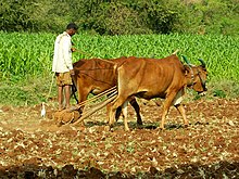
Greengram, bengalgram, blackgram, paddy, groundnut, wheat, redgram, sugarcane and chillies are other agricultural crops.
[26] However, the agriculture of Bidar, like that of many other semi-arid regions which produced dry cereals, was considered to be "low productive" and has been subject to a variety of "development programmes" that have drawn, largely, on the agenda of the Green Revolution.
Gradually between the late 1960s and mid-1970s hybrid varieties of seeds for other crops such as cotton, pulses and sunflower were introduced.
In geo-physical terms Bidar district is part of the semi-arid and drought-prone belt of northern Karnataka and has been susceptible to periodic droughts.
[26] The district has eight talukas, Bidar, Humnabad, Bhalki, Aurad, Hulsoor, Chitgoppa, Kamalnagar and Basavakalyan.