Bierbach an der Blies
[3] Except for small patches of land that are close to the river on the Bliestal, the ground is mainly composed of sandstone, which makes it difficult to be used for growing food crops.
Within a radius of 10 km (6.2 mi), six larger towns can be easily reached: Blieskastel, Homburg, Zweibrücken, St. Ingbert, Neunkirchen and Bexbach.
The area of Bierbach was probably already inhabited in prehistoric times during the paleolithic era, as finds such as a hand-axe that was found in Blieskastel and is dated 200000 BCE would indicate.
Traces of his missionary activity in the area can be found in the names of some of the places, streets and buildings in Bierbach.
A different hypothesis stipulates that the development of the name is related to the remains of Roman buildings in the area of Bierbach.
Similar name evolutions can also be seen in other places such as Bierbach in the Odenwald [de], in which case "Burbach" as it was called in 1314 CE transitioned into "Bierbach" in 1748 CE, where similarly the first part of the name derives from "bûrea" and the second part denominates a creek.
At that time he documented the name of today's "Bierbach" to be "Beurbach", which would be the linguistic sound evolution from "Bûribach".
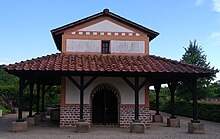
In the courtyard, at the opposite side of the pillar row, stood a splendidly decorated grave monument.
However, there was no interest at that time to make the finds accessible to the public and transform the area into an archaeological zone.
After evaluating the finds it was concluded, that the twin temples was dedicated to the God Mercury and his wife Rosmerta.
[18] The first documented mention of Bierbach is found in a property exchange deed of the neighboring monastery Wörschweiler in 1230.
However, from June 16 of that same year, it was placed under the Imperial-Royal Austrian and Royal Bavarian Joint Land Administration Commission.
After the lost First World War the Treaty of Versailles of 1919 ordered the separation of western areas of the Palatinate.
They were assigned to the newly formed Saar area, which in turn was placed under the administration of the League of Nations.
Thus, Homburg, St. Ingbert and a part of the county of Zweibrücken to which Bierbach belonged were incorporated into the new Saar area.
On 11 June 1923, the renovated church building was consecrated by Bishop Ludwig Sebastian and named Herz Jesu Kirche.
After World War II, the number of Catholics living in Bierbach grew rapidly and the remodeled church became too small.
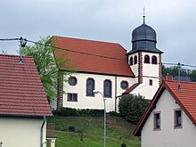
[23] The Protestant Church of Bierbach[24] is located on a southern slope in the midst of the old village with a view over the Bliestal.
The building was designed by C. M. Rey from Kaiserslautern as a simple hall construction with a short choir room and an attached bell tower.