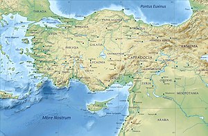
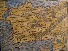
Bithynia
It bordered Mysia to the southwest, Paphlagonia to the northeast along the Pontic coast, and Phrygia to the southeast towards the interior of Asia Minor.
Several major cities sat on the fertile shores of the Propontis (which is now known as Sea of Marmara): Nicomedia, Chalcedon, Cius and Apamea.
The most important mountain range is the (so-called) "Mysian" Olympus (8,000 ft, 2,400 m), which towers above Bursa and is clearly visible as far away as Istanbul (70 miles, 110 km).
The broad tract which projects towards the west as far as the shores of the Bosporus, though hilly and covered with forests—the Turkish Ağaç Denizi, or "The sea of Trees"—is not traversed by any mountain chain.
Extensive plantations of mulberry trees supply the silk for which Bursa has long been celebrated, and which is manufactured there on a large scale.
The Thyni and Bithyni appear to have settled simultaneously in the adjoining parts of Asia, where they expelled or subdued the Mysians, Caucones and other minor tribes, the Mariandyni maintaining themselves in the northeast.
[2] The Bithynians were incorporated by king Croesus within the Lydian monarchy, with which they fell under the dominion of Persia (546 BC), and were included in the satrapy of Phrygia, which comprised all the countries up to the Hellespont and Bosporus.
[1] Even before the conquest by Alexander the Bithynians appear to have asserted their independence, and successfully maintained it under two native princes, Bas and Zipoites, the latter of whom assumed the title of king (basileus) in 297 BC.
His son and successor, Nicomedes I, founded Nicomedia, which soon rose to great prosperity, and during his long reign (c. 278 – c. 255 BC), as well as those of his successors, Prusias I, Prusias II and Nicomedes II (149–91 BC), the kings of Bithynia had a considerable standing and influence among the minor monarchies of Anatolia.