Wilhelmina Bay
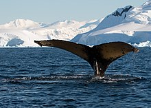
[2] Coastal features include, clockwise from the eastern entrance, A study undertaken in May 2009 found a super-aggregation of krill in Wilhelmina Bay, with a large number of humpback whales feeding on them.
[3] Wilhelmina Bay was discovered by the Belgian Antarctic Expedition (BelgAE) of 1897–99 led by Adrien de Gerlache.
Named by the UK Antarctic Place-Names Committee (UK-APC) in 1960 for Leonardo da Vinci (1452-1519), artist, musician, architect and first aeronautical scientist.
Named by the UK-APC in 1960 after James Sadler (1751-1828), Oxford confectioner, the first English aeronaut, who ascended in a montgolfier balloon on October 4, 1784.
A point on the west coast of Graham Land projecting into Wilhelmina Bay southeast of Pelseneer Island.
Named by the UK-APC in 1960 for André-Jacques Garnerin (1770-1825), French aeronaut, the first man to make a successful descent from a free balloon by parachute, in 1797.
Named by the UK-APC in 1960 for Charles-François Beautemps-Beaupré (1766-1854), French hydrographer who, in 1825, prepared survey instructions for the officers of the Astrolabe and Zelee, laying down for the first time principles for making measurements from landscape drawings.
A point within Wilhelmina Bay, lying 6 nautical miles (11 km; 6.9 mi) southeast of Cape Anna.
Named by the UK-APC in 1960 for Sir Bennett M. Jones, F.R.S., author of Aerial Surveying by Rapid Methods, a pioneer work on the subject.
Named by the UK-APC in 1960 for Carl Reinhard Hugershoff (1882-1941), German geodesist who designed the autocartograph, an instrument which first applied the principles of photogrammetry to air photos, in about 1921.
A prominent black cape rising to 280 metres (920 ft) high, forming the north tip of Arctowski Peninsula on the west coast of Graham Land.
Discovered by the BelgAE, 1897-99, and named by Gerlache for Paul Pelseneer, member of the Belgica Commission and writer of some of the zoological reports of the expedition.