List of Pennsylvania state parks
Three are "Conservation Areas": Boyd Big Tree Preserve, Joseph E. Ibberson, and Varden; four are "Environmental Education Centers": Jacobsburg, Jennings, Kings Gap (also a "Training Center") and Nolde Forest; White Clay Creek is a "Preserve"; Norristown is a "Farm Park"; and Big Spring is a "State Forest Picnic Area".
[6] Seven parks are undeveloped with no facilities: Allegheny Islands, Benjamin Rush, Bucktail, Erie Bluffs, Prompton, Swatara, and Varden; the last four of these are in the process of being developed.
Five state parks are small picnic areas: Laurel Summit, Patterson, Prouty Place, Sand Bridge, and Upper Pine Bottom.
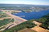
Five state parks have major U.S. Army Corps of Engineers dams and/or lakes: Bald Eagle, Beltzville, Elk, Kettle Creek, and Sinnemahoning.
[7][d] According to the DCNR, the state parks in Pennsylvania are on more than 300,000 acres (120,000 ha) with some 606 full-time and more than 1,600 part-time employees serving approximately 36 million visitors each year.
Parks were added sporadically until the 1930s, some mere camping and picnic areas in state forests, while others preserved unique sites.
[11] The 1930s saw a great expansion of parks and their facilities under Governor Gifford Pinchot, who cooperated with President Franklin Roosevelt, despite their being of different political parties.
This was thanks largely to the efforts of Maurice K. Goddard, who served as director of the precursors to the DCNR for twenty-four years under six administrations.
In modern times, some "State Parks" have become "Environmental Education Centers", while other parks have dropped one word from their name ("Cherry Springs Drive" is now Cherry Springs, "Codorus Creek" is now Codorus, "Kooser Lake" is now Kooser, "Laurel Hill Summit" is now Laurel Summit, and "Promised Land Lake" is now Promised Land).