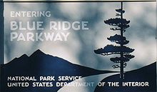
Blue Ridge Parkway
The roadway continues through Shenandoah as Skyline Drive, a similar scenic road which is managed by a different National Park Service unit.
There is no fee for using the parkway; however, commercial vehicles are prohibited without approval from the Park Service Headquarters, near Asheville, North Carolina.
[6][7] The roadway is not maintained in the winter, and sections that pass over especially high elevations and through tunnels are often impassable and therefore closed from late fall through early spring.
Outside of the Asheville, Boone and Roanoke areas, it largely avoids major population centers, and the road parallels several US and Interstate Highways along sections of its route, which are generally used for longer haul traffic.
The use of interchanges and grade separation at cross roads is designed to allow for freer flowing traffic and better vistas than frequent intersections and stoplights would allow for.
Major towns and cities along the way include Waynesboro, Roanoke, and Galax in Virginia; and in North Carolina, Boone and Asheville, where it runs across the property of the Biltmore Estate.
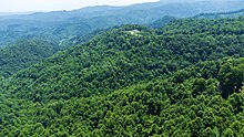
[9] The highest point on the parkway (south of Waynesville, near Mount Pisgah in North Carolina) is 6,053 feet (1,845 m) above sea level on Richland Balsam at milepost 431.
[10] Sections of the parkway may be temporarily closed to repair damage caused by the cold winter climate of the mountains or for other maintenance.
[9] The parkway's natural resource protection protocol limits the use of ice melting chemicals, and certain areas could remain closed for extended periods.
Begun during the administration of President Franklin D. Roosevelt, the project was originally called the Appalachian Scenic Highway.
Original plans called for the parkway to connect Shenandoah National Park and Great Smoky Mountains National Park with the parkway either turning west into Tennessee at Linville, North Carolina, or continuing southward through North Carolina.
Secretary of the Interior Harold L. Ickes put together a three-person panel to study the possible routes the parkway could take.
[16] The Bruce Bowers documentary The Blue Ridge Parkway: The Long and Winding Road gives Congressman Robert Doughton the credit for getting the route changed.
On June 30, 1936, Congress formally authorized the project as the Blue Ridge Parkway and placed it under the jurisdiction of the National Park Service.
Crews from the Emergency Relief Administration carried out landscape work and development of parkway recreation areas.
During World War II, the CCC crews were replaced by conscientious objectors in the Civilian Public Service program.
[18] They were not permitted to use the parkway for any commercial travel but were required to transport equipment and materials on side roads.
[19] Specifically, the revised bill "specified the parkway route, assured the $40,000 payment for the tribe's land, and required the state to build [a] regular highway through the Soco Valley".
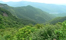
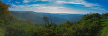
[26][27] Flowering shrubs and wildflowers dominate the parkway in the spring, including rhododendrons and dogwoods, moving from valleys to mountains as the cold weather retreats.
[28] Often in early-to-middle October and middle to late April, all three seasons can be seen simply by looking down from the cold and windy parkway to the green and warm valleys below.
The Blue Ridge Parkway has also been a corridor for the spread of many invasive species, including oriental bittersweet, privet, and multiflora rose.