Blueseed
The original idea of Blueseed was to create a startup community located on a vessel stationed in international waters near the coast of Silicon Valley in the United States.
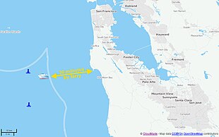
[5] The initial intended location (outside the territorial seas of the United States, 12 nautical miles (24 kilometers) from the coast of California, in the so-called "contiguous zone") would enable non-U.S. startup entrepreneurs to work on their ventures without the need for a US work visa (H1B), while living in proximity to Silicon Valley and using relatively easier to obtain business and tourism visas (B1/B2)[6] to travel to the mainland.
The project received wide media coverage and the promise of funding from venture capitalist Peter Thiel,[7] who also supports the Seasteading Institute, who ultimately did not invest in the seed round.
[3] The stated motivations of the project included providing an entrepreneurial alternative to the Startup Visa Act[12] and creating "a vibrant workplace for innovative industries to bloom, unencumbered by onerous regulations on new technology-sector businesses".
[9] On July 31, 2013, two years after its founding, Blueseed co-founder Marty announced that he was stepping down from his day-to-day activities at the company and taking the role of Chairman of the Board of Directors.
[22][23][24] A Los Angeles Times article about Blueseed noted that another company called SeaCode, led by Roger Green and David Cook, had attempted something similar in the past but had to put the project aside because they were unable to raise enough money to launch.
[25] Blueseed planned to either convert a cruise ship or remodel a barge[5] in order to provide living accommodations, coworking space, and entertainment facilities for approximately 1,000 customers[26] paying an average of USD 1500 in monthly rent[14] (ranging between $1200 and $3000, and combined with a small equity stake[27]).