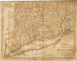
Border disputes between New York and Connecticut
Though the dispute was officially resolved in 1731, effects of the boundary conflict persisted until well after both colonies gained statehood as part of the United States following the American Revolution.
The dispute originated largely as an extension of a wider ongoing conflict between the colonial ambitions of benefactors of the Dutch Republic and the Kingdom of England.
Much of the Dutch jurisprudence was based on the writings of the legal scholar Hugo Grotius, who emphasized claiming the land and interaction with the natives.
When Henry Hudson had first explored the area in 1609, he was employed by the Dutch, so the Netherlands could base its claim on both first discovery and status as financial backer.
By contrast, the exploding population of the neighboring New England Colonies placed ever more farms and settlements across Connecticut and Long Island Sound.
The English believed the Dutch had endangered the "adjoining Countries most wickedly, feloniously, and traitorously, contrary to the Marine and Admirall Laws of all Christians, [by selling] wholesale guns, powder, shot and ammunition to the Indians, instructing them in the use of our fights and arms.
"[2] The Dutch claim to the land was further weakened when Peter Stuyvesant justified trading guns by citing pressure from the natives.
As part of the agreement, announced in December 1664, the main land was divided “by the consent” of the commissioners with a north-northwest line at the mouth of the Mamaroneck River.
In 1665, Commissioner George Cartwright reported, “The Bounds betwixt the Dukes province and Connecticut were mistaken by wrong Information, for it was not intended they should come nearer to Hudsons river then 20 miles, Yett the line was sett doune by the Commissioners to goe from such a Point Nor-nor-west whereas it ought to goes just North, otherwise the line will go into Hudsons river.”[7] In 1675, a New York review of the boundary claimed there was a verbal agreement that the line should be at all times 20 miles from the Hudson; and in 1683, Gov.
Winthrop objected, Andros sent a representative in June to demand Connecticut's submission, threatening to send soldiers against any rebellion.
Andros requested that Winthrop temporarily relinquish Connecticut's claim to the area in order to strengthen the united defense.
John Pell, a Westchester justice, granted a warrant requiring the constables of Rye, Greenwich, and Stamford to appear at a NY Court of Assizes in Oct 1683.
As the Dominion of New England became a reality and quo warranto proceedings were begun against the Connecticut charter in 1686, Gov.
A month later, in November, some of these men were made to appear in New York courts and “acknowledge their fault in making their addresses to the Colony of Connecticut to be taken into that pretended Government.”[15] In 1693, Gov.
Fletcher commanded a Connecticut militia in Hartford as part of an intercolonial defense force called for in the royal commission.
For example, the Philipse family owned all of what is now Putnam County, New York, but did not enforce their ownership of the land within the Oblong, allowing hundreds of squatters to move in, mostly from Connecticut.
These settlers were allowed to stay for decades, and a small village even sprung up on the Philipse land (now the hamlet of Patterson, New York).


