Borders of Suriname
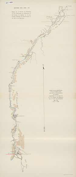
There were no problems with this decision until 1885, when the discovery of gold in the area between the Lawa and the Tapanahony created a new border conflict.
Tsar Alexander III of Russia, acting as the arbitrator, decided that the Lawa was the headwater of the Maroni, and thus should be considered the border.
A protocol delineating the border from the mouth of the Maroni up to the village of Antecume Pata was attached to this treaty on 15 March 2021.
[2] The Litani originates in the Tumuk Humak Mountains at approximately 2½° N 55° W; along its path it is fed by Koele Koelekreek, the Lokekreek, the Mapaonikreek and the Oelemari River.
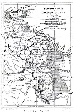
In 1799, however, Berbice governor Abraham Jacob van Imbijze van Batenburg and Suriname governor Jurriaan François de Friderici signed an agreement in which the western bank of the Courantyne River was demarcated as the boundary.
The Netherlands, however, raised a diplomatic protest, claiming that the New River, and not the Kutari, was to be regarded as the source of the Courantyne and the boundary.
In 1936, a Mixed Commission established by the British and Dutch government agreed to award the full width of the Courantyne River to Suriname, as per the 1799 agreement.
The treaty putting this agreement into law was never ratified, because of the outbreak of World War II.
In 1969 border skirmishes occurred between Guyanese forces and Surinamese militias at Camp Tigri.
Until present Guyana hasn't withdrawn any of its military forces and still holds a firm grip on the New River Triangle.
[citation needed] The maritime boundary has long been disputed between Guyana and Suriname as well, and led in 2000 to skirmishes between Guyanese oil explorers and Surinamese coast guards.
The border described in the treaty was the result of an arbitration process that was headed by King Victor Emmanuel III of Italy.