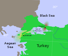
Bosporus
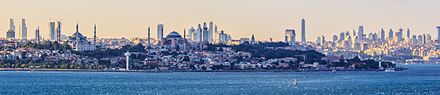
Most of the shores of the Bosporus Strait, except for the area to the north, are heavily settled, with the city of Istanbul's metropolitan population of 17 million inhabitants extending inland from both banks.
[7] This is a reference to the Greek mythological story of Io, who was transformed into a cow and condemned to wander the Earth until she crossed the Bosporus, where she met the Titan Prometheus, who comforted her by telling her that she would be restored to human form by Zeus and become the ancestor of the greatest of all heroes, Heracles (Hercules).
The 12th-century Greek scholar John Tzetzes calls it Damaliten Bosporon (after Damalis), but he also reports that in popular usage the strait was known as Prosphorion during his day,[10] the name of the most ancient northern harbour of Constantinople.
[11] The term eventually came to be used as the common noun βόσπορος, meaning "a strait", and was also formerly applied to the Hellespont in Classical Greek by Aeschylus and Sophocles.
[17] Dan Parsons and researchers at the University of Leeds School of Earth and Environment describe a Black Sea undersea river.
Then in August 2010, a continuous 'underwater channel' of suspension composition was discovered flowing along the floor of the Bosporus, which would be the sixth largest river on Earth if it were on land.
[19]The central tenet of the Black Sea deluge hypothesis is that as the ocean rose 72.5 metres (238 ft) at the end of the last Ice Age when the massive ice sheets melted, the sealed Bosporus was overwhelmed by a spectacular flood that increased the then fresh water Black Sea Lake by 50%, and drove people back from the shores for many months.
This hypothesis was supported by the findings of undersea explorer Robert Ballard, who discovered settlements along the old shoreline; scientists dated the flood to 7500 BP or 5500 BC from fresh-salt water microflora.
Driven out by the rapidly rising water, which must have been terrifying and inexplicable, people spread to all corners of the Western world carrying the story of a major flood.
As the waters surged, they scoured a network of sea-floor channels less resistant to denser suspended solids in liquid, which remains a very active layer today.
In 2002, a survey carried out on board the Ifremer RV Le Suroit for BlaSON project (Lericolais, et al., 2003[21]) completed the multibeam mapping of this underwater channel fan-delta.
In the 5th century BC the Greek city-state of Athens, which depended on grain imports from the Black Sea ports of Scythia, maintained critical alliances with cities which controlled the straits, such as the Megarian colony of Byzantium.
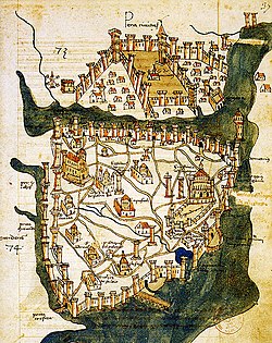
The Byzantines called the Bosporus "Stenon" and used the following major toponyms in the area:[26] The strategic significance of the strait was one of the factors in the decision of the Roman Emperor Constantine the Great to found his new capital, Constantinople, there in AD 330.
Under the Treaty of Hünkâr İskelesi of 8 July 1833, the Bosporus and Dardanelles straits were to be closed to the naval vessels of other powers on Russian demand.
[30] During the 19th century many of the foreign powers represented in Constantinople maintained second embassies up the Bosporus and would relocate their staff there during the hot, humid summer months.
Most of these summer embassies were on the European shore at Yeniköy (Austrian), Tarabya (German, English, French, Italian) and Büyükdere (Spanish, Russian).
[31] Following the First World War, the 1920 Treaty of Sèvres demilitarised the strait and made it an international territory under the control of the League of Nations.
That convention - which is still in force - treats the straits as an international shipping lane except that Turkey retains the right to restrict the naval traffic of non–Black Sea states.
Turkey was neutral in the Second World War until February 1945, and the straits were closed to the warships of belligerent nations during this time, although some German auxiliary vessels were permitted to transit.
[37] The Bosphorus takes its name from the Greek mythological story of Io, who was transformed into a cow and, pursued by a gadfly, was condemned to wander the Earth until she reached the strait.
There she met the Titan Prometheus, who comforted her by telling her that she would be restored to human form by Zeus and become the ancestor of the greatest of all heroes, Heracles (Hercules).
Their destructive power was finally overcome by the Argonaut hero Jason who managed to pass between them unscathed, whereupon the rocks became fixed, opening Greek access to the Black Sea.
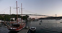
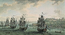
The Bosporus is traversed by numerous passenger and vehicular ferries daily, as well as by recreational and fishing boats ranging from dinghies to yachts owned by both public and private entities.
Compounding these difficult changes in trajectory, the rear and forward sight lines at Kandilli and Yeniköy are also completely blocked prior to and during the course alteration, making it impossible for ships approaching from the opposite direction to see around the bends.
The risks posed by this geography are further multiplied by the heavy ferry traffic across the strait, linking the European and Asian sides of the city.
In 2011, the Turkish Government started to discuss creating a man-made canal roughly 80 kilometres (50 mi) long that would run north–south through the western edges of Istanbul Province as a second route from the Black Sea to the Marmara.
Most of the public ferries that traverse the strait leave from Eminönü on the historic peninsula of Istanbul and travel as far as Anadolu Kavağı near the Black Sea.
Frequent public ferries from Eminõnü, Karaköy, Beşiktaş, Kadıköy and Usküdar offer short hops from one side of the Bosporus to the other throughout the day.
[53] Catamaran sea buses offer high-speed commuter services between the European and Asian shores of the Bosporus, but they stop at fewer ports and piers in comparison to the public ferries.
[citation needed] During the late 19th and early 20th centuries, the Egyptian royal family took a great liking to the Bosporus and often spent their summers on its shores.