Boundary markers of the original District of Columbia
Working under the supervision of three commissioners that President George Washington had appointed in 1790 in accordance with the federal Residence Act, a surveying team led by Major Andrew Ellicott placed these markers in 1791 and 1792.
[1] Today, 36 of the original marker stones survive as the oldest federally placed monuments in the United States.
The north-south axis of the District's current boundaries extends southward from the District's north corner near East-West Highway (Maryland Route 410), travels between 17th and 18th Streets, N.W., and continues south across the National Mall to the far shore of the Potomac River; the east-west axis is between the present Constitution Avenue and C Street, N.E.
The center of the square is west of the Ellipse and north of the Mall, within the grounds of the headquarters of the Organization of American States.
[4] In 2011, the District of Columbia geographic information system (GIS) program completed a project to map the District's boundary using Global Positioning System (GPS) and contemporary survey technology at an accuracy of ±5 centimetres (2.0 in) horizontally and ±9 centimetres (3.5 in) vertically.
[2][8][9] On April 15, 1791, officials dedicated the south corner stone in an elaborate Masonic ceremony at a point that Andrew Ellicott had determined.
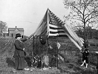
[12] The side of a boundary marker that faced the federal territory was inscribed "Jurisdiction of the United States" and with the distance in miles and poles from the previous corner stone.
Ellicott's report described the marker stones and contained a map that showed the boundaries and topographical features of the Territory of Columbia.
[16] In 1909, Ernest A. Shuster of the United States Geological Survey wrote an article for the National Geographic Magazine that described his visits to the 36 remaining boundary stones and that urged their protection and preservation.
[21] This boundary marker in Falls Church, Virginia was added to the National Register of Historic Places, and further was named a U.S. National Historic Landmark, in 1976 at the instigation of the Afro-American Bicentennial Corporation, which gave the stone its name: Benjamin Banneker: SW-9 Intermediate Boundary Stone.
[23] This boundary marker in Virginia was added to the National Register of Historic Places in 1980, together with Alexandria's Jones Point Lighthouse.
These boundary markers in Virginia were added to the National Register of Historic Places on February 1, 1991 in response to the Multiple Property Submission cited above.
These boundary markers, located along the border between the District of Columbia and Maryland, were added to the National Register of Historic Places on November 1, 1996.
The Committee included representatives of the State of Maryland and of Arlington and Fairfax counties and the cities of Alexandria and Falls Church in Virginia.
[26] In 2008, the NVRC announced that four Virginia local governments, including Arlington and Fairfax counties and the cities of Alexandria and Falls Church, had agreed to help fund a project to protect and preserve the boundary stones by providing matching funds to a Transportation Enhancement Grant that the District Department of Transportation (DDOT) had received from the Federal Highway Administration (FHA).
The announcement stated that the NVRC was working on an agreement with the DDOT, the National Park Service and the FHA to administer the project.
[12] Download coordinates as: A group of entrance markers, erected later along major roads that travel into the District of Columbia, are located on or near the boundary of D.C. and Maryland.