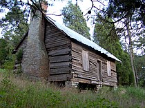
Brabson's Ferry Plantation
[5] Brabson's sons continued operating the plantation after his death, and established a business that catered to the ferry's traffic.
The Brabson Cemetery is located atop a steep hill with a sweeping view of the French Broad River on the north end of the plantation.
Highway 338 follows what was once a stretch of the Great Indian Warpath, a trail used for centuries by Native Americans travelling up and down the Tennessee Valley.
The ancient path crossed the French Broad River at a ford near the mouth of Boyds Creek.
In 1780, John Sevier crossed at this ford to engage and defeat a Cherokee force at the Battle of Boyds Creek.
John Brabson, who migrated to the area from Frederick County, Virginia, purchased the Evans farm and ferry in 1798.
[8] John Brabson's daughter, Mary, and son-in-law, Robert H. Hodsden, established the Rose Glen plantation in the 1840s just east of Sevierville.
Toward the end of the war, as Union forces re-gained control of East Tennessee, vengeful Sevier Countians began harassing and threatening the Brabsons.
In an October 1865 letter, Benjamin Brabson's wife, Elizabeth (1821–1894), wrote, "they rocked my house so, burned my carriage, and fired my outbuildings, they also shot at me several times."
The Brabson farm produces beef cattle, wheat, oats, corn, hay, and soybeans.
Both houses contain most of their original design elements, including large post-and-lintel mantels and open "dog-leg" staircases.