Bramble Cay
[2] Lying around 50 km (31 mi) north of Erub Island in the Gulf of Papua, it is the northernmost point of land of Australia and marks the end of the Great Barrier Reef.
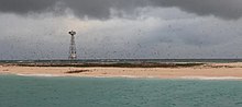
The island was formed around a "basalt outcrop produced by Pleistocene volcanic activity and is composed of foraminiferal sand, compacted guano and, at its south-eastern end, a low phosphatic rock platform".
[4][8] The cay marks the entrance to the Great North East Channel through the Torres Strait, which has made it significant to human history.
[11] It was demolished in 1954 and replaced by the present lighthouse, a 17-metre (56 ft) stainless steel tower,[12] which was equipped with solar power on 6 January 1987.
The Papua New Guinean city of Daru, the capital of Western Province, is some 70 kilometres (43 mi) west of Bramble Cay.
[citation needed] Bramble Cay is the closest island to the mouth of the Fly River in PNG (at around 55 kilometres (34 mi) southeast).
[21] Customary tenure of Bramble Cay is held by the people of Erub (Darnley), the closest inhabited island, 45 kilometres (28 mi) south-southwest.
[9] In August 2021, a group of artists from Erub Island created a series of works called Maizab Kaur Mukeis (the Meriam Mir name for the Bramble Cay melomys), consisting of sculptures of the animal made with ghost nets.
The work was inspired by the news of its extinction, with the artists hoping to create awareness of the damage caused by the abandoned fishing nets to marine ecosystems.
The work was selected as one of four Queensland finalists for the National Aboriginal and Torres Strait Islander Art Awards (NATSIAA).