Breezy Point, Queens
[1] Breezy Point is patrolled by the 100th Precinct of the New York City Police Department;[4] its ZIP Code is 11697.
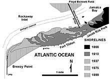
This isolated, 200-acre (0.81 km2) area includes an ocean-facing beach, a shoreline on Jamaica Bay, sand dunes, and marshland.
[5] Based on data from the 2010 United States Census, the population of the combined area of Breezy Point/Belle Harbor/Rockaway Park/Broad Channel was 28,018, an increase of 1,307 (4.9%) from the 26,711 counted in 2000.
The residents of the community purchased half of the land for approximately $11 million and formed the Breezy Point Cooperative.
[12] Breezy Point is patrolled by its own private security force that restricts access to owners, renters and their guests.
On September 8, 2012, the community was struck by a tornado shortly before 11 a.m. that started as a waterspout over the Atlantic Ocean and came ashore at the Breezy Point Surf Club.
Most Breezy Point homes were damaged or destroyed by high water, and basements and vehicles were ruined.
[15] According to an official report in December, rising seawater caused the fire by contacting a house's electrical wires.