Bregenz Forest Mountains
As the range is not geologically uniform, the name is rarely used outside of Alpine literature, is also not used in Vorarlberg state geography and land-use planning and belongs to one of the most disputed mountain groups in the AVE.
The Bregenzerwald mountain range is located in the far northwest of the Eastern Alps, east of the lower Alpine Rhine Valley and southeast of Lake Constance.
During this period, the Penninic Ocean lay where the Alps are today, and thick limestone deposits formed on its northern edge, the Helvetic Shelf, over the course of millions of years.
On the other hand, there are the softer, marly Drusberg layers, which weather easily and thus provide a favorable breeding ground for forests and alpine pastures, as can be seen particularly impressively on the Hoher Freschen.
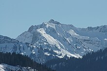
Kanisfluh and Mittagsfluh stand out in the middle of this area, consisting of Jurassic limestone and thus the oldest rocks in the Bregenzerwald mountains.
During the Upper Cretaceous, large quantities of sand were washed from the Central Alps, which were still below sea level at the time, into a deep-sea channel of the Pennine Ocean.
It is still present as a northern flysch zone in a narrow strip north of the line Dornbirn - Gütle - Andelsbuch - Sibratsgfäll, i.e. mainly in the Hochälpele-Weißenfluh group, and also as a southern flysch zone south of the line Feldkirch - Satteins - Innerlaterns - Damülser Mittagsspitze - Schoppernau, particularly in the eastern Walser ridge, in the southern Damüls mountains and in the Glatthorn group, and beyond that in individual islands in between, most clearly recognizable in the summit of the Hohe Kugel.
The mountains of the flysch zone, which are all gently shaped due to the soft rock, are therefore covered with forests and meadows, even on the steepest slopes up to the summits.
The Bregenzerwald mountains north of the line Dornbirn - Egg - Hittisau, i.e. essentially the area of the Lorenaberge, consist of Subalpine Molasse, which was formed - relatively late for the Alps - in the Neogene.
The Via Alpina, a cross-border hiking trail with five partial routes through the whole Alps, runs along the edge of the Bregenzerwald mountain range.