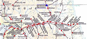
Bremenium
The fort is part of the defensive system built along the extension of Dere Street, a Roman road running from York to Corbridge and onwards to Melrose.
The fort is situated in the village of Rochester, five miles (8.0 km) north-west of Otterburn on the A68 road between Corbridge and Jedburgh.
It was one of the forts along Dere Street, and positioned to defend this main supply and transit route to the north.
In 79 AD Agricola moved against the Brigantes of northern England and the Selgovae along the southern coast of Scotland, using overwhelming military power to establish Roman control.
The line of military communication and supply across southeastern Scotland and northeastern England was Dere Street (on which Bremenium was located) which was well-fortified.
In the 120s Hadrian established the frontier further south by building his wall, and Bremeniun remained outside it as an "outpost" fort.
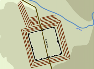
The site is in a strong position, occupying the end of a ridge with the ground falling away steeply to the north and west, and giving a clear view over the Rede Valley and beyond.