Brewster County, Texas
The three leading Mescalero chiefs, Patula Grande, Quemado, and Zapato Tuerto, agreed in March 1789 to submit to Spanish rule.
[8] Northern Mexican military governor Lt. Col. Hugo Oconór led a 1772 expedition to locate sites for forts on the Comanche Trail along the Rio Grande.
[9][10] In October 1851, Danish-born Col. Edvard Emil Langberg, Mexican commandant of Chihuahua, visited southern Brewster County.
[12] An 1859 expedition of the U.S. Camel Corps under 2d Lt. Edward L. Hartz explored the Comanche Trail through Persimmon Gap and down Tornillo Creek to the Rio Grande.
[13] In response to threats of ongoing Indian attacks, Camp Peña Colorado was established in 1879 a few miles south of the future site of Marathon.
[14] Word of mouth about the open rangeland in the area was spread by freighters John W Burgess and August Santleben, leading the way for settlers.
[15] The Galveston, Harrisburg and San Antonio Railway built through the area in 1882, opening up opportunity for entrepreneurs who came on railroad-related business and stayed.
[17][18][19] Legendary lawman and later Texas Rangers Hall of Fame member James B. Gillett served as sheriff of Brewster County, and operated a ranch in Alpine in the late 19th and early 20th centuries.
[5] From the turn of the 20th century through World War II, the Terlingua Mining District, west of the Chisos Mountains, was a boom town due to the extraction of cinnabar, a mercury ore. Silver and lead from mines on the Mexican side of the river in the Boquillas area were shipped north, as were candelilla wax produced at factories at Glenn Spring and Mariscal, and the guayule rubber from a factory in Marathon.
President Wilson mobilized the National Guard to reinforce the Army, and by the end of 1916, an estimated 116,957 guardsmen were stationed along the border from California to Texas.
[26] The geographic region known as the Big Bend is a loosely defined section of the Trans-Pecos, although generally agreed to comprise its more southern portions.
Characterized by an extremely rugged, arid Chihuahuan Desert landscape, the region takes its name from the sharp northeastward turn made by the Rio Grande nearby.
The World Championship Chili Cookoff at Terlingua began as a tongue-in-cheek challenge between Fowler and humorist H. Allen Smith in 1967 and has become a November tradition, celebrated across the state and nation.
The Roadian Age of the Permian Period of geological time is named for rock strata in Road Canyon in the northern part of the county.
[35] Temperatures are coolest and rainfall most abundant in the county's northern highlands and in the upper elevations of the Chisos Mountains in the south.
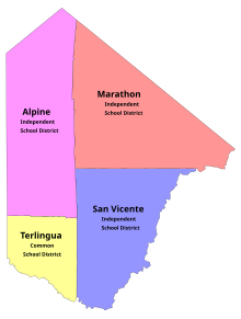
These school districts serve Brewster County:[52] In addition, Sul Ross State University is located in Alpine.
However, unlike the rest of southern Texas, the county swung towards Joe Biden in the 2020 election, albeit by less than one percent with both candidates gaining in vote percentage.