British Columbia Highway 99
[4][5] The highway passes the Peace Arch monument in the international park of the same name and travels north through a 24-hour customs facility operated by the Canada Border Services Agency in Douglas, part of southern Surrey on Boundary Bay.
[11][12] The freeway turns northwest and passes through a junction with Highway 17A before it enters the George Massey Tunnel, which travels under the South Arm of the Fraser River from Deas Island to Richmond.
Highway 99 briefly travels west onto Marine Drive after an interchange and crosses the Capilano River to the Park Royal Shopping Centre, where it turns north onto Taylor Way.
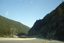
[8][28] Highway 99 travels northeast through Murrin Provincial Park as it ascends a hill to bypass Watts Point, an extinct volcanic centre on Howe Sound.
It bypasses downtown to serve a commercial and industrial area on the north side of the city and briefly turns northeast to cross the Mamquam River.
East of the pass the road follows the course of Cayoosh Creek as it traverses the southern base of Mount Rohr and skirts Duffey Lake Provincial Park.
The modern-day highways between the Peace Arch Border Crossing and New Westminster generally follow the Semiahmoo Trail, an overland route used by indigenous Coast Salish peoples that was later adopted by fur traders and early non-indigenous Fraser Valley settlers in the 1860s.
[34] The Pacific Highway was later built in the 1910s to connect Vancouver to Seattle and the rest of the U.S. West Coast and marked by the Peace Arch, a monument dedicated in 1921 to commemorate the Treaty of Ghent.
[58] It cost $1.3 million to construct and replaced a winding coastal section of Marine Drive,[59] but initially lacked guardrails and other safety features due to a rushed opening.
[65][66] The new highway was built alongside the government-owned Pacific Great Eastern Railway (now BC Rail), which completed an extension along Howe Sound to Squamish on August 27, 1956, to connect with an existing route to Prince George.
[69][70] Surveyors began work in 1949 to find a suitable route along Howe Sound to link existing roads that ended at Whytecliff (overlooking Horseshoe Bay) and Britannia Beach.
[83][88] An estimated 9.5 million tonnes (21,000,000,000 lb) of material was blasted or excavated for the highway project, which was delayed by a year due to the reassignment of labour to finish the Pacific Great Eastern Railway.
[92] The majority of the two-lane highway was paved in July through a rush order from the provincial government to complete a preliminary surface, while 24 kilometres (15 mi) between Britannia and Squamish remained a gravel road with steeper grades and narrower turns.
[97][98] The provincial government announced plans pave the Britannia–Squamish section and extend the highway to Pemberton and Lillooet by 1965 following requests from local business leaders.
[99][100] The existing route from Squamish to Lillooet was 90 kilometres (56 mi) long and mostly unpaved, with some sections that required vehicles with four-wheel drive to negotiate the terrain.
[101] Construction of an all-season gravel road to Alta Lake at the base of Whistler Mountain was announced in March 1962 as part of a larger development plan for a ski area that could host the Winter Olympics.
[121][122] A tunnel at the Deas Island site, which would replace an existing ferry and cost up to $17 million, was announced as the winning option in February 1956 following a recommendation from a contracted engineering firm.
[132] The freeway alignment of Highway 99 between 8th Avenue in South Surrey and the North Arm of the Fraser River opened in 1962 and was originally named the Deas (Island) Throughway.
[137][138] The 90-kilometre (56 mi) road was widened to a width of 7.3 metres (24 ft) and opened to the public on weekends and outside of logging periods to access recreational areas and bypass the congested Fraser Canyon highways.
During construction, a group from the Lil'wat First Nation blockaded the road at Mount Currie during a conflict with Lillooet residents and authorities; the 9-kilometre (5.6 mi) section through the community was left unpaved for several years.
[citation needed] The portion of the highway between Lillooet and Pavilion was part of the route of the Old Cariboo Road, which was developed in the 1850s and 1860s during the Fraser Canyon Gold Rush.
[147] Fatalities on the section were attributed to inclement weather conditions that changed rapidly,[146] poor visibility, excessive speed, drunk drivers, and difficulty in passing slower vehicles.
[148] A major reconstruction of the highway, including widening sections to four lanes between Horseshoe Bay and Squamish, was proposed by political leaders in 1981 following the death of nine people who had driven off a washed out wooden bridge over M Creek.
[151] The bid also considered a new highway to bypass parts of the corridor, including a tunnel under Grouse Mountain or a toll road through Indian Arm, but they were not advanced for further planning.
[154] The project cost $600 million and included the construction of large retaining walls, wider bridges able to withstand earthquakes, and mesh screens for rockfalls.
A court injunction and police were used to remove the protestors, one of whom, Harriet Nahanee, a respected Squamish elder, died soon after in the Surrey Pre-Trial Centre from health complications alleged to be related to her arrest and incarceration.
[158][159] Plans to build a new highway through West Vancouver to directly connect the Lions Gate Bridge to the Upper Levels Freeway were rejected by the provincial government following a study that determined it would not be cost-effective.
[157] During the Olympic Games, a checkpoint was installed on Highway 99 near Squamish to inspect travellers to Whistler, who were required to present a valid permit for parking provided by their hotel or issued to residents and workers.
[168][169] Proposals to build an alternative Burrard Inlet road crossing to replace the Lions Gate Bridge have been announced by various business groups and political leaders since the 1930s, with more serious studies undertaken in the late 1960s and early 1970s.
The Vancouver Park Board approved of an agreement with TransLink, the city and provincial governments, and ICBC in 2000 to allow the widening on the condition that private vehicular traffic on the causeway and Lions Gate Bridge would be banned in 2030 if a new crossing were built.