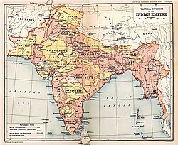
Presidencies and provinces of British India
[5] However, the power of the Mughal Empire declined from 1707, first at the hands of the Marathas and later due to invasion from Persia (1739) and Afghanistan (1761); after the East India Company's victories at the Battle of Plassey (1757), and Battle of Buxar (1764)—both within the Bengal Presidency established in 1765—and the abolition of local rule (Nizamat) in Bengal in 1793, the company gradually began to formally expand its territories across India.
Independence from British rule was achieved in 1947 with the formation of two nations, the Dominions of India and Pakistan, the latter including East Bengal, present-day Bangladesh.
At its greatest extent, in the early 20th century, the territory of British India extended as far as the frontiers of Persia in the west; Afghanistan in the northwest; Nepal in the north, Tibet in the northeast; and China, French Indochina and Siam in the east.
[13] Meanwhile, in eastern India, after obtaining permission from the Mughal Emperor Shah Jahan to trade with Bengal, the company established its first factory at Hoogly in 1640.
[14] After Robert Clive's victory in the Battle of Plassey in 1757, the puppet government of a new Nawab of Bengal, was maintained by the East India Company.
[16] Portions of the Kingdom of Mysore were annexed to the Madras Presidency after the Third Anglo-Mysore War ended in 1792.
Next, in 1799, after the defeat of Tipu Sultan in the Fourth Anglo-Mysore War more of his territory was annexed to the Madras Presidency.
[17] By 1851, the East India Company's vast and growing holdings across the sub-continent were still grouped into just four main territories: By the time of the Indian Rebellion of 1857, and the end of Company rule, the developments could be summarised as follows: The British Raj began with the idea of the presidencies as the centres of government.
In 1950, after the new Indian constitution was adopted, the provinces in India were replaced by redrawn states and union territories.