Names of the British Isles
For this reason, the name British Isles is avoided by some, as such usage could be interpreted to imply continued territorial claims or political overlordship of the Republic of Ireland by the United Kingdom.
According to A. L. F. Rivet and Colin Smith in 1979 "the earliest instance of the name which is textually known to us" is in The Histories of Polybius, who referred to them as: τῶν αἱ Βρεταννικαί νήσοι, romanized: tōn hai Bretannikai nēsoi, lit.
[33] The fourth chapter of the first book of the Bibliotheca historica of Diodorus Siculus describes Julius Caesar as having "advanced the Roman Empire as far as the British Isles" (Greek: προεβίβασε δὲ τὴν ἡγεμονίαν τῆς Ῥώμης μέχρι τῶν Βρεττανικῶν νήσων, romanized: proebíbase dè tḕn hēgemonían tês Rhṓmēs mékhri tôn Brettanikôn nḗsōn)[34] and in the 38th chapter of the third book Diodorus remarks that the region "about the British Isles" (τὸ περὶ τὰς Βρεττανικὰς νήσους, tò perì tàs Brettanikàs nḗsous) and other distant lands of the oecumene "have by no means come to be included in the common knowledge of men".
[37] According to Snyder, the Greek: Πρεττανοί, romanized: Prettanoí derives from "a Gallo-Brittonic word which may have been introduced to Britain during the P-Celtic linguistic innovations of the sixth century BC".
[43] In his Orbis descriptio, Dionysius Periegetes mentions the British Isles and describes their position opposite the Rhine delta, specifying that there are two islands and calling them the "Bretanides" (Βρετανίδες, Bretanídes or Βρεταννίδες, Bretannídes).
[44]In his Ars tactica, Arrian referred to "people living in the islands called "Britannic" which belong to the Great Exterior sea" (οἱ ἐν ταῖς νήσοις ταῖς Βρεττανικαῖς καλουμέναις τῆς ἔξω τῆς μεγάλης θαλάσσης, hoi en taîs nḗsois taîs Brettanikaîs kalouménais tês éxō tês megálēs thalássēs) as being the only people in the world still to use war chariots.
[48]: 143, 146 In the fifth chapter of the seventh book of Geography, Ptolemy describes the British Isles as being at the northern limits of the oecumene: "in the north, the oecumene is limited by the continuation of the ocean which surrounds the British Isles and the northernmost parts of Europe" (ἀπ’ ἄρκτων δὲ τῷ συνημμένῳ Ὠκεανῷ, τῷ περιέχοντι τὰς Βρεττανικὰς νήσους καὶ τὰ βορειότατα τῆς Εὐρώπης, ap’ árktōn dè tôi sunēmménōi Ōkeanôi, tôi periékhonti tàs Brettanikàs nḗsous kaì tà boreiótata tês Eurṓpēs).
[49]: 744 In the third chapter of the eighth book of Geography, Ptolemy summarizes the content of his maps, stating that "The first map of Europe includes the British Isles and the surrounding islands" (Ὁ πρῶτος πίναξ τῆς Εὐρώπης περιέχει τὰς Βρεττανικὰς νήσους σὺν ταῖς περὶ αὐτὰς νήσοις, Ho prôtos pínax tês Eurṓpēs periékhei tàs Brettanikàs nḗsous sùn taîs perì autàs nḗsois).
In the grammatical treatise he dedicated to the emperor Marcus Aurelius (r. 161–180), De prosodia catholica, Aelius Herodianus notes the differences in spelling of the name of the British Isles, citing Ptolemy as one of the authorities who spelt the name with a pi (Ancient Greek: π, romanized: p): "Brettanídes islands in the Ocean; and some [spell] like this with pi, Pretanídes, such as Ptolemy" (Βρεττανίδες νῆσοι ἐν τῷ Ὠκεανῷ· καὶ ἄλλοι οὕτως διὰ τοῦ π Πρετανίδες νῆσοι, ὡς Πτολεμαῖος, Brettanídes nêsoi en tôi Ōkeanôi; kaì álloi hoútōs dià toû p Pretanídes nêsoi, hōs Ptolemaîos).
[60] Rzach suggested that Procopius of Caesarea referred to these lines when mentioning in his De Bello Gothico that the Sibylline Oracles "foretells the misfortunes of the Britons" (Ancient Greek: προλέγει τὰ Βρεττανῶν πάθη, romanized: prolégei tà Brettanôn páthē).
In manuscript copy of the classical Armenian adaptation published in 1880 by the Mekhitarists of San Lazzaro degli Armeni, the British Isles are Բրետանացւոց կղզիք, Bretanacʿwocʿ kłzikʻ,[72] which in the Latin translation of 1887 is Britannicae insulae.
[103] The noun Britoun (variously spelled Britton, Briton, Bryton, Brytoun, Bruton, Brutun, Brutin, Breton, Bretonn, or Britaygne) meant "a native of the British Isles".
[104] The English texts of the popular work Mandeville's Travels mention Great Britain in the context of the invention of the True Cross by Helena, mother of Constantine I, who was supposed to be a daughter of the legendary British king Coel of Colchester.
[106] The chronicler John Stow in 1575 and the poet William Slatyer in 1621 each cited the spelling of "Brutayne" or "Brytayne" in Mandeville's Travels as evidence that Brutus of Troy was the origin of the name of the British Isles.
[113] The Annals of the Four Masters's report on the death of Fothad I under the year 961 describes him as Fothaḋ, mac Brain, scriḃniḋ ⁊ espucc Insi Alban, 'Fothadh, son of Bran, scribe and Bishop of Insi-Alban'.
[133] John Stow, citing Aethicus Ister, Mandeville's Travels, and Geoffrey of Monmouth, described the naming of Great Britain and the British Isles by Brutus of Troy (Early Modern English: Brute) in his 1575 work A Summarie of the Chronicles of England.
[132]: 594 According to Holinshed himself in the second chapter (Of the auncient names of this Islande) of the first book (An Historicall Description of the Islande of Britayne, with a briefe rehearsall of the nature and qualities of the people of Englande, and of all such commodities as are to be founde in the same) of the first volume of the Chronicles, Brutus had both renamed Albion after himself and given his name to the British Isles as a whole: ... Brute, who arriving here in the 1127, before Christ, and 2840. after the creation, not onely chaunged it into Britayne (after it had bene called Albion, by the space of 595. yeares) but to declare his sovereigntie over the reast of the Islandes also that are about the same, he called them all after the same maner, so that Albion was sayde in tyme to be Britanniarum insula maxima, that is, the greatest of those Isles that bare the name of Britayne.Eryn:Hiberniae,BritannicaeInsulæ, NovaDescriptioIrlandtThe geographer and occultist John Dee (of Welsh ancestry)[135] was an adviser to Elizabeth I (r. 1558–1603) and prepared maps for several explorers.
[141]: 85–86 Invoking the Cosmography of Aethicus and its supposed translator Jerome, Dee argued that the British Isles had been misnamed, noting:[142] St Hierome his admiration of ethicus his assert[ion] that these Iles of albion and irelande sho[ld] be called brutanicae & not britannicaeAccording to Peter J. French, "Like Leland, Lhuyd and other antiquarians, Dee believed that it was mistakes in orthography and pronunciation that had confused the spelling of the name", which had come from the name of Brutus.
The supposed alteration in spelling had caused:[142] the [origin] all Di[s] coverer & Conqueror, and the very first absolute king of these Septentrionall brytish Islands, to be forgotten: or some wrong person, in undue Chronography, with repugnant circumstances, to be nominated in our brutus the italien trojan, his stede.In his copy of John Bale's Scriptorum illustrium maioris Brytanniae catalogus (later in Christ Church Library), at Bale's passage on Gildas, Dee had added an annotation on Brutus, stating: "Note this authority of Gildas concerning Brutus and Brytus, and remember that from the most ancient authority of the astronomer Aethicus, they were called the Brutish Islands" (Nota hanc Gildae authoritatem de Bruto et Bryto, et memor esto de Ethici astronomi authoritate antiquissima, insulas Brutanicas dictas esse)".
Speed describes the position of "the Iland of Great Britaine" as being north and east of Brittany, Normandy, and the other parts of the coast of Continental Europe:[150] It hath Britaine, Normandy, and other parts of France upon the South, the Lower Germany, Denmarke, and Norway upon the East; the Isles of Orkney and the Deucaledonian Sea, upon the North; the Hebrides upon the West, and from it all other Ilands, and Ilets, which doe scatteredly environ it, and shelter themselves (as it were) under the shadow of Great Albion (another name of this famous Iland) are also accounted Britannish, & are therefore here described altogetherIn his 1621 verse work Palæ-Albion: The history of Great Britanie from the first peopling of this island to this present raigne of or happy and peacefull monarke K: James, William Slatyer described the British Isles as named "the Brutus Iles in Greeke Dialect".
J. Mandevill.One of the Oxford English Dictionary citations of "British Isles" was in 1621 (before the civil wars) by Peter Heylin (or Heylyn) in his Microcosmus: a little description of the great world[151] (a collection of his lectures on historical geography).
Writing from his English political perspective, he grouped Ireland with Great Britain and the minor islands with these three arguments:[152] Modern scholarly opinion[20][21] is that Heylyn "politicised his geographical books Microcosmus ... and, still more, Cosmographie" in the context of what geography meant at that time.
[158] Under this Title are Comprehended several distinct and famous Islands, the whole Dominion whereof (now United) is under the Command of the King of Great Britain, &c. Bounded on the North and West with the Hyperborean and Ducalidonean Ocean, on the South divided from France with the English Channel, on the East seperated [sic] from Denmark and Belgia with the British (by some call'd the German) Ocean; But on all sides environed with Turbulent Seas, guarded with Dangerous Rocks and Sands, defended with strong Forts, and a Potent Navy; Of these Islands one is very large, formerly called Albion, now great Britain, comprehending two Kingdoms, England and Scotland; and another of lesser extent makes one Kingdome called Ireland: The other smaller adjacent Isles are comprehended under one or other of these 3 Kingdoms, according to the Situation and Congruity with them.Christopher Irvine, in his 1682 Historiae Scoticae Nomenclatura Latino-Vernacula, 'Latin–Vernacular Nomenclature of the History of Scotland', defined Britannice Insulæ [sic] as "The British Islands; which comprehended under them both Albin, Erin, and all the other small islands that are scattered about them".
Beginning with "At last, someone has had the sense to abolish the British Isles", he opines that "although purely a geographical definition, it is frequently mixed up with the political entities Great Britain, or the United Kingdom.
[183][177][184] Steven G. Ellis, however, Canny's successor as professor of history at the same university from 2009, wrote in 1996: "with regard to terminology, 'the British Isles', as any perusal of contemporary maps will show, was a widely accepted description of the archipelago long before the Union of the Crowns and the completion of the Tudor conquest of Ireland".
[191] In September 2005, Dermot Ahern, minister for foreign affairs, stated in a written answer to a parliamentary question from Caoimhghín Ó Caoláin in the Dáil Éireann: "The British Isles is not an officially recognised term in any legal or inter-governmental sense.
[204] A bilingual dictionary website maintained by Foras na Gaeilge translates "British Isles" into Irish as Éire agus an Bhreatain Mhór "Ireland and Great Britain".
[220]His comments were echoed by Proinsias De Rossa, then leader of the Democratic Left and later President of the Irish Labour Party, who told the Dáil, "The acronym IONA is a useful way of addressing the coming together of these two islands.
J. G. A. Pocock, in his lecture of 1973 entitled "British history: a Plea for a new subject" and published in 1974, introduced the historiographical concept of the "Atlantic archipelago – since the term 'British Isles' is one which Irishmen reject and Englishmen decline to take quite seriously".
Sensitive to such susceptibilities, proponents of the idea of a genuine British history, a theme which has come to the fore during the last couple of decades, are plumping for a more neutral term to label the scattered islands peripheral to the two major ones of Great Britain and Ireland."


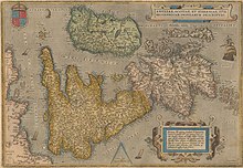

Eryn :
Hiberniae,
Britannicae
Insulæ, Nova
Descriptio
Irlandt


