Brooks Peninsula Provincial Park
As a result of land-use planning for Vancouver Island, this former 28,780 hectare (71,117 acre) recreation area (established in 1986) was upgraded in 1995 to a Class 'A' Provincial Park.
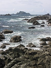
Brooks Peninsula juts 20 kilometres (12 mi) into the Pacific Ocean and has a rugged and varied coastline, with long fjords and sandy beaches.
As a result, the geology of the peninsula is different from that of the rest of Vancouver Island and many rare plant communities exist, providing unparalleled opportunities for scientific study.
The Brooks-Nasparti addition encompasses the entire watershed of the Nasparti River and streams draining into Johnson Lagoon, the west-facing slopes along Nasparti Inlet, the Power River and Battle Creek watersheds and the Mount Seaton area The park preserves the peninsula's pristine wilderness landscape, which contains the Refugium Range of the Vancouver Island Ranges and Coastal Western Hemlock biogeoclimatic zone.
Camping is permitted anywhere in the park, but made complicated due to the remoteness, difficulty of access, and lack of facilities.