Buchanan County, Iowa
[2] The county was created in 1837 and was named in honor of Senator James Buchanan, the 15th President of the United States.
It was named after US Senator James Buchanan, who would later go on to be President of the United States.
[10] As of the census[11] of 2000, there were 21,093 people, 7,933 households, and 5,672 families residing in the county.
24.70% of all households were made up of individuals, and 12.50% had someone living alone who was 65 years of age or older.
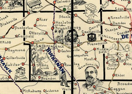
A number of historic communities in Buchanan County once appeared on state maps, but no longer exist.
Hamerville was located east of Brandon at the intersection of Highway 150.
Vista, once located between Brandon and Independence, appeared on maps frequently until the 1950s.
Several towns named Middlefield existed southeast of Winthrop, but none are populated today.
Wise, once located between Independence and Jesup just north of Highway 939, was a train-stop between the 1920s and the 1950s.
The exceptions were 1864, 1912 (when former Republican Theodore Roosevelt ran as a Progressive, allowing Democrat Woodrow Wilson to win the county with a sub-40% plurality), the two landslide elections of Franklin D. Roosevelt in 1932 and 1936, and the landslide election of Lyndon B. Johnson in 1964.