Bude
[6] It lies southwest of Stratton, south of Flexbury and Poughill, and north of Widemouth Bay, located along the A3073 road off the A39.
Bradshaw's Guide of 1866, Section 2, described Bude as: "a small port and picturesque village in the north-eastern extremity of Cornwall".
"The sea view is of a striking, bold and sublime description – the rocks rising on every side to lofty broken elevations".
[10] Part of the land designated as the Bude Coast Site of Special Scientific Interest is owned by the National Trust.
The cliffs around Bude are the only ones in Cornwall that are made of Carboniferous sandstone, as most of the Cornish coast is formed of Devonian slate, granite and Precambrian metamorphic rocks.
The figurehead of one of these, the Bencoolen, a barque whose wrecking in 1862 resulted in the drowning of most of the crew, was preserved in the churchyard but was transferred to the town museum to save it from further decay.
[14] Like the rest of the British Isles and South West England, Bude experiences a maritime climate with cool summers and mild winters.
[16] The Met Office recorded Bude as the sunniest place in the United Kingdom during the summer of 2013 with 783 hours of sunlight.
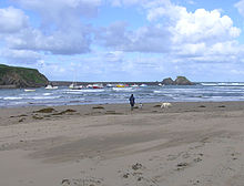
The spectacular sandstone coast here is a Site of Specific Scientific Interest, known for jagged reefs, implicated in many past shipwrecks.
The two halves of the town are connected by Nanny Moore's bridge, a grade two listed building,[23] named after a 19th-century ‘dipper’ who lived nearby.
Bude and neighbouring Stratton are relevant in the English Civil War, with Nanny Moore's Bridge featuring as a passe over the river for the Royalists.
North Cornwall District Council administered the canal, harbour and lock gates until its abolition in March 2009.
Its original purpose was to take small tub boats of mineral-rich sand from the beaches at Bude and carry them inland for agricultural use on fields.
The arrival of the railway at Holsworthy and the production of cheap manufactured fertiliser undermined the canal's commercial purpose, and it was closed down and sold to the district municipal water company.
However the wharf area and harbour enjoyed longer success, and coastal sailing ships carried grain across to Wales and coal back to Cornwall.
Bude Castle was built about 1830 on sand on a concrete raft for Victorian inventor Sir Goldsworthy Gurney and is now a heritage centre.
At the northernmost point of Efford Down Farm, overlooking Summerleaze Beach and the breakwater, a former coastguard lookout stands.
Known as Compass Point and built by the Acland family in 1840 of local sandstone, it is based on the Temple of Winds in Athens.
[30][31][32] Reviews facetiously compared the tunnel to the Taj Mahal, Hanging Gardens of Babylon and Great Sphinx of Giza.
Bude railway station was served by the Atlantic Coast Express, providing a direct service to/from London Waterloo, until it was discontinued in 1964.
The Bude area is also a telecommunications hub, with major subsea cables landing at nearby Widemouth Bay.
Since Cornwall became a unitary authority in 2009 there has been a two-tier structure of local government: Cornwall Council (administers, for example, schools and highways, housing, social services, canal and harbour, refuse and recycling collection, street cleanliness; the town is represented by the Bude division) and Bude-Stratton Town Council (local children's playground, Bude "castle").
Bude is the host town of the North Cornwall Cup, a large youth football event held every August.