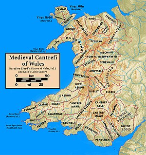
Buellt
[1][2] Situated in the valley of Afon Irfon, Buellt's boundaries were roughly the Cambrian Mountains to the north, the River Wye to the east, the Mynydd Epynt range to the south, and Ceredigion to the west.
[7][8][9] The Historia recounts that after Vortigern had invited the Anglo-Saxons to Britain and then been forced west, his son Pascent ruled Buellt and Gwrtheyrnion as a grant from Ambrosius Aurelianus.
[10] Whatever the reality of this story, another section attributes descent from Pascent and Vortigern to Ffernfael ap Tewdwr, a 9th-century ruler of Buellt and Gwrtheyrnion known from other sources.
During the Norman invasion of Wales, the Marcher Lord Philip de Braose conquered Buellt shortly after he took Rhwng Gwy a Hafren in 1095.
[16] Philip fortified the hill east of present-day Builth Wells with a wooden motte and bailey castle and held the area until his death in 1134, when it passed to his son William.
[15] The area changed hands between multiple Norman and Welsh figures, including Roger Mortimer, Rhys ap Gruffudd and Llywelyn the Great.
In the 16th century, as part of Henry VIII's Laws in Wales Acts, Buellt became a hundred and merged with Brycheiniog into the new county of Brecknockshire.