Bullengraben
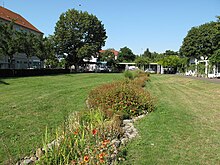
Parallel to the moat, the Deutsche Bahn subsidiary created the 200-meter-wide green corridor with playgrounds and sports fields, recreational areas, bridges, footbridges, and a path that leads to Elsflether Weg.
Additionally, biotopes located within the green corridor, such as the Stieglake and Wiesen basins, along with the ditches leading to them, such as the Egelpfuhlgraben, have undergone restoration.
The Bullengraben Green Corridor, a recently established site, is located approximately one hundred meters towards the east at Nennhauser Dam.
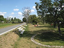
A metallic bridge provides access to the lowland which leads to a small settling basin that is considered a symbol of the source of the Bullengraben.
A total of 17 bridges cross the Bullengraben, including several smaller wooden or metal footbridges connecting allotments and neighboring settlements.
[1] Beyond the Elsflether Weg, the ditch and green corridor continue east for about 50 meters before ending at the back of the large Klosterstrasse development.
The green corridor is interrupted but resumes to the southeast at Ziegelhof Street, following the Burgwallgraben which begins at this point and reaches the Havel River after about 300 meters in a semicircular path.
After the end of the Ice Age, soil rich in peat and limestone meadow deposits developed to the west of the Havel channel due to alluvial sedimentation processes.
The large lowland area was previously very wet and frequently flooded but was eventually drained into the Havel through ditches like the Bullengraben and the Spekte.
[2][3] The Bullengraben, which was most likely artificially created in a glacial flow channel, has been used since the Slavic settlement of Havelland in the 7th century, to effectively improve the wet lowlands west of Havel.
[6] However, Winfried Schich has cast doubt on these claims, stating that there is no evidence to support them:[7] "In Spandau, archaeologists believe they can reconstruct further canalized waterways beyond the Havel and Spree in the course of the Spekte and Bullengraben lowlands leading westwards.
The historian can say just as little about this as he can about the question of whether the Mark Brandenburg cultural landscape with its numerous ditches and ramparts was even the legacy of a Bronze Age colonization with an agricultural irrigation system, as Klaus Goldmann believes.
[8] The Burgwall Island, which was one of the biggest archaeological excavation sites in Berlin/Brandenburg at the end of the 20th century, served as the focal point of the Slavic settlement chamber of Spandau.
Nine small houses were laid out at Krummen Gärten in the 15th century, likely becoming the first residential buildings in the area outside of Staaken, the monastery, and Spandau city walls.
[12] Around 1580, Rochus zu Lynar, the master builder of the citadel, obtained the nuns' farmland and began growing wine on the site.
After demolishing the old brick kiln on Stresow, Elector Georg Wilhelm commissioned the construction of a new council brickwork on the former monastery grounds in Spandau.
Outflanked by the emerging brick-making centers of Glindow and Werder, the town demolished the brick kiln in 1755 and replaced it with a fruit tree plantation.
The area experienced frequent flooding from the nearby Havel and Bullengraben rivers, leading the tenants to adopt an agricultural and gardening lifestyle.
With pH values of 4.2 and 6.2 (up to 7 in Weidenbruch and Egelpfuhlwiese), the nutrient supply for shallow-rooted plants in the upper soil layers ranged from low to medium during the study period.
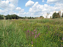
A dense carpet of common duckweed-covered water bodies such as the meadow basin or the willow marsh at the ditch cross during the overflow phases in spring.
The state of Berlin lists the false cypergrass sedge and the knotted rush in the early warning stage[28] The faunal research team, who conducted investigations in 1988/1989, categorized the highly urbanized region as having no significant impact on the population of most animal species.
[30] The grass frog, which is no longer on the current Berlin Red List due to a continuous good population development since 1991, was also observed by the working group at the meadow basin.
The meadow basin also formed a spawning area for the strictly nocturnal spadefoot toad, which the German Society for Herpetology and Terrarial Science named amphibian of the Year in 2007 due to its severe endangerment.
Another frog, the European green toad, which is strictly protected under the Habitats Directive, used the bottom of the watercourse to lay its spawning lines.
In the wetland biotopes, there were high proportions of phytophagous and hygrophilous species, including the endangered Berlin black moth (Agonum lugens),[32] which prefer eutrophic or mesotrophic sedimentation zones.
In addition, there was evidence of the endangered large Chrysochraon dispar, which prefers wetlands and fresh to moderately dry meadows, in the Weidenbruch.
The disc-shaped Gelippte Tellererschnecke found in the ponds at Egelpfuhl meadows and Weidenbruch is noteworthy as an endangered species in Berlin's aquatic ecosystem.
[38][39] Since the early 1980s, the Spandau district authority has been planning the development and redevelopment of the neglected Bullengraben and the renaturation of its protected biotopes.
[43] At a ceremony held by the Berlin Senate on 20 May 2009, Deutsche Bahn was awarded the Gustav Meyer Prize 2008 for the design of the green corridor in the category for facilities up to five years old.
There is a gap in the pathway and green space network between Lindenufer and the Tiefwerder Wiesen landscape conservation area on the southeastern side of the Havel River.