Bundjalung people
The Bundjalung people, also spelled Bunjalung, Badjalang and Bandjalang, are Aboriginal Australians who are the original custodians of a region from around Grafton in northern coastal New South Wales to Beaudesert in south-east Queensland.
The names of the 15 tribal groups comprising the Bundjalung Nation are Arakwal,[1] Banbai, Birbai, Galiabal, Gidabal, Gumbainggeri, Jigara, Jugambal, Jugumbir (Yugembeh), Jungai, Minjungbal, Ngacu, Ngamba, Nyangbal[6][7] and Widjabal/Wiyabal.
[10][circular reference] Cook failed to notice the entrance to the Richmond River, but noted the presence of about 20 Bundjalung Nation Aboriginal people on what is now Seven Mile Beach, just to the south of Broken Head.
Word rapidly spread about the wonderful red cedar timber which made small fortunes for the men of the Richmond River.
[15] Aboriginal ancestors of the people who make up the Bundjalung Nation first arrived on the North Coast of NSW thousands of years ago.
The minimum time by which this migration had taken place is confirmed at 12,000 years ago, with the upper bound (or earliest period) remaining a matter of some unresolved contention.
As the ice caps melted at the end of the Pleistocene Epoch about 12,000 years ago (10,000 BC), sea levels rose and covered a strip of land off the east coast of Australia, leaving high relief terrain exposed as a coastal promontory.
In Bundjalung National Park at an Aboriginal midden on the banks of the Evans River, is a Western Kurrajong tree that is estimated to be more than 360 years old.
The Marriage Tree as it is called by Bundjalung Aboriginals, was a gift from the Wahlubal tribe at Tabulam, when a wedding took place at Gummigurrah between a man and a woman.
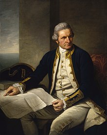
The coast in the vicinity of Evans Head was first mapped and described by Lieutenant James Cook FRS RN of the United Kingdom on HMS Endeavour.
Cook also noted a pair of small islands, naming the two main peaks Julian Rocks after his nephew and niece, Juan and Julia.
Lieutenant James Cook FRS RN, was the first European to record in his diary of seeing "… a remarkable sharp peaked Mountain lying inland…"[17] from a point of land he named Cape Byron.
Lieutenant James Cook FRS RN, did not know that the Bundjalung people for many miles around called the mountain 'Wulambiny Momoli', and that it was an important sacred site, as their lives and religion were strongly linked to the land.
There situation may always be found by the peaked mountain before mentioned which bears SWBW from them this and on this account I have named Mount Warning it lies 7 or 8 Leagues inland in the latitude of 28°..22" S° the land is high and hilly about it but it is conspicuous enough to be distinguished from everything else.
[19] The Black Bean or Moreton Bay Chestnut (Castanospermum australe) has proved valuable to Europeans as a timber species, its seeds have been utilised – following extensive preparation as a food by Aborigines and it contains alkaloids which have been shown to have anti-HIV and anti-cancer properties.
High rainfall and humid conditions, injuries and insect attack was a major health hazard causing serious infection that may result in death.
The indigenous native Bundjalung Nation Aboriginals of eastern Australia exposed to the same harsh conditions with little or no protection were observed crushing tea tree leaf and binding it over wounds and infections with paper bark strapping.
In addition, the indigenous native Bundjalung Nation Aboriginal people used "tea trees" as a traditional medicine by inhaling the oils from the crushed leaves to treat coughs and colds.
Historically ‘Bungawalbyn Valley Basin' is the birthplace of the 'TEA TREE INDUSTRY' and over a period of time world populations were introduced to this unique 'natural' antiseptic.
Still to this day, modern science has failed to provide a safe effective medication for the treatment of topical infections and fungal diseases compared to ‘Australian Native Tea Tree Oil'.
The original sheep run in what is now the Lismore area was located on the north arm of the Richmond River, and the station covered 23,000 acres (93 km2), taken up by Captain Dumaresq around 1843.
The sheep which were herded down from New England found the wetter sub-tropical climate not to their liking, and the losses caused by fluke, foot rot and other diseases led to the abandonment of the run.
In 1853–4, at an area close to the present day East Ballina Golf Course, the Native Police slaughtered at least 30 – 40 Bundjalung Nation Nyangbal Aboriginal men, women and children while they slept.
At 3 am the next morning the Native Mounted Police patrol rode out to where between 200 and 300 Bundjalung Nation Nyangbal Aboriginal tribes people lay asleep in camp.
The NSW Government took no action against the perpetrators and told the Europeans settlers 'to mind their own business and warned that persistence in the matter might lead to trouble for them', hence there are no official records of the massacres.
When the Aboriginal survivors eventually returned to the camp, they sought no reprisals and took no revenge against the Native Mounted Police involved in the massacre.
The oral tradition includes stories of escape, of people who were shot and were laid to rest in the forests north of the camp, and of those who were driven off the cliff at Black Head.
Aboriginals were stopped from raising their own children, from freedom of movement, having access to education, receiving award wages, marrying without permission, eating in restaurants, entering a pub, swimming in a public pool or having the right to vote.
Emu callers (short didgeridoos about 30 centimetres (12 in) long) were traditionally used by the Bundjalung when hunting (Eastern Australia Coastal Emus).


The Duke of Richmond
KG, PC

(Alexandrina Victoria; 24 May 1819 – 22 January 1901) was the Queen of the United Kingdom of Great Britain and Ireland from 20 June 1837, and the first Empress of India of the British Raj.