Bushwick, Brooklyn
It is bounded by the neighborhood of Ridgewood, Queens, to the northeast; Williamsburg to the northwest; the cemeteries of Highland Park to the southeast; and Bedford–Stuyvesant to the south and southwest.
[8][9] Prior to the merger, in the early 19th century, residential development in the area had begun when the new district of Williamsburg was laid out in western Bushwick.
[14] The centroid, or geographic center, of New York City is located on Stockholm Street in Bushwick, on the block between Wyckoff and St. Nicholas Avenues.
The community was settled, though unchartered, on February 16, 1660, on a plot of land between the Bushwick and Newtown Creeks[17] by fourteen French and Huguenot settlers, a Dutch translator named Peter Jan De Witt,[19] and one of the original eleven slaves brought to New Netherland, Franciscus the Negro, who had worked his way to freedom.
[23] Contemporary reports differ on the reason: T. W. Field writes that "a nice functionary of the [Brooklyn] City Hall ... contemptuously thrust them into his waste-paper sacks",[24] while Eugene Armbruster claims that the movable bookcase containing the records "was coveted by some municipal officer, who turned its contents upon the floor".
New Bushwick Lane (Evergreen Avenue), a former Native American trail, was a key thoroughfare for accessing this new tract, which was suitable mostly for potato and cabbage agriculture.
Bushwick Shore's favorable location close to New York City led to the creation of several farming developments.
[33] In October 1867, the American Institute awarded Bushwick Chemical Works the first premium for commercial acids of the greatest purity and strength.
[35] It made a variety of bottles and jars, as well as large numbers of glass electrical insulators for telegraph, telephone and power lines.
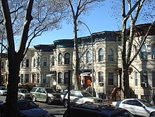
[46] Bushwick homes were designed in the Italianate, Neo Greco, Romanesque Revival, and Queen Anne styles by well-known architects.
In particular, the Sicilian townsfolk of Menfi, Santa Margherita di Belice, Trapani, Castelvetrano, and many other paesi had their own clubs (clubbu) in the area.
St. Joseph Patron of the Universal Church Roman Catholic Parish was the hub of the Sicilian community, and held five feasts during the year, complete with processions of saints or Our Lady of Trapani.
Rising energy costs, advances in transportation and the change to the use of aluminum cans encouraged beer companies to move out of New York City.
Another contribution to the change in the socioeconomic profile of the neighborhood was the John Lindsay administration's policy of raising available rent for welfare recipients.
New immigrants continued to move to the area, many from Hispanic America, but renovation and new construction was outpaced by the demolition of unsafe buildings, forcing overcrowded conditions at first.
As buildings came down, the vacant lots made parts of the neighborhood look and feel desolate, resulting in a greater outflow of residents and a growth of the illegal drug trade due to a lack of job opportunities.
[53] Author Jonathan Mahler described the social and economic hardships of Bushwick after the blackout in his book Ladies and Gentlemen, the Bronx is Burning, explaining that the majority of neighborhood residents were living on less than $4,000 a year, and had to rely on some form of public assistance.
[55] In the wake of reduced crime rates citywide and a shortage of affordable housing in nearby neighborhoods such as Park Slope and Williamsburg, numerous young professionals and artists have moved into converted warehouse lofts, brownstones, limestone-brick townhouses, and other renovated buildings in Bushwick.
[60] A Bushwick-centered news site, entitled Bushwick Daily, was founded in 2010 by Katarina Hybenova, and features community issues, events, food, art and culture.
The group's goal was to improve quality of life in the twenty-three square blocks surrounding Maria Hernandez Park through various programs such as addressing deteriorated housing conditions, increasing economic development opportunities, and reducing drug dealing activities.
The Bushwick Initiative's economic development efforts were also focused on revitalizing the Knickerbocker Avenue commercial district, and adding a thousand rat-resistant public trash cans to reduce litter.
Since the turn of the 21st century, the population of native-born Americans has increased, as have other Latino groups, particularly immigrants from Mexico and El Salvador.
[81] A campus of Boricua College and a branch of the Puerto Rico-based Popular Community Bank are located within the Bushwick area.
[82] So important is the activism of local Latinos that in 2016, Democratic Party presidential candidate Bernie Sanders campaigned in Bushwick in order to reach Hispanic votes.
[64]: 14 The concentration of fine particulate matter, the deadliest type of air pollutant, in Bushwick is 0.0081 milligrams per cubic metre (8.1×10⁻⁹ oz/cu ft), higher than the citywide and boroughwide averages.
Because the Arbitration Rock lay along a diagonal with this grid plan, numerous houses were built on the Brooklyn-Queens boundary, their owners sometimes subject to taxes from both counties.
[127] Bushwick is located in the New York City Council's 34th and 37th districts,[5] represented respectively by Democrats Jennifer Gutiérrez and Sandy Nurse.
There are also community centers Nightclubs include Bushwick generally has lower ratios of college-educated residents than the rest of the city as of 2018[update].
[159][160][161] During the 1960s, under the direction of Robert Moses, there were plans to build an extension of Interstate 78 through Bushwick, to connect lower Manhattan with the South Shore of Long Island.
[162] The extension was to be called the Bushwick Expressway, but was never built, due to then Mayor John V. Lindsay's concerns that traffic leaving Manhattan should bypass it via the Verrazzano-Narrows Bridge and the project was formally killed by Governor Nelson Rockefeller in 1971.